Heiligenhafen geodata
Heiligenhafen (Schleswig-Holstein) is a populated place; located in Germany in Europe/Berlin (GMT+2) time zone. With population of 9,308 people, there are 1734 cities with bigger population in this country. Compared to other cities in Germany, 97.1% of cities are located further ↓South; 66.7% of cities are located further ←West and 92.3% of cities have higher elevation than Heiligenhafen. Note1
Administrative division(s):
- Level 1: Schleswig-Holstein
- Level 3: Kreis Ostholstein
- Level 4: Heiligenhafen


Heiligenhafen GPS coordinates[2]
54° 22' 10.704" North, 10° 58' 48.792" East
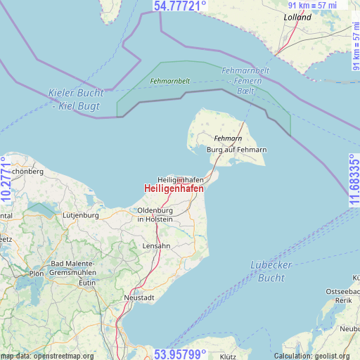
| Map corner | latitude | longitude |
|---|---|---|
| Upper-left | 54.77721°, | 10.2771° |
| Center: | 54.36964°, | 10.98022° |
| Lower-right: | 53.95799°, | 11.68335° |
| Map W x H: | 91.1×91.1 km | = 56.6×56.6mi |
| max Lat: | 55.01917° ⇑2.9% North |
| Heiligenhafen: | 54.36964° |
| min Lat: | ⇓97.1% South 47.40724° |
| min Long | Heiligenhafen | max Long |
| 5.92978° | 10.98022° | 14.98853° |
| W 66.7%⇐ | ⇒33.3% E |
Elevation
Elevation of Heiligenhafen is 15 m = 49 ft, and this is 234.1 m = 768 ft below average elevation for this country.
| Max E: |
1256 m = 4121 ft | 92.3% |
| Avg. | 249.1 m = 817 ft | |
| Heiligenhafen | 15 m = 49 ft | |
Min E: |
-5 m = -16 ft | 7.7% |
See also: Germany elevation on elevation.city.
Geographical zone
Heiligenhafen is located in North temperate zone (between Tropic of Cancer and the Arctic Circle). Distance of this North polar circle is 1355.8 km =842.5 mi to North.| Distance of | km | miles | from Heiligenhafen |
|---|---|---|---|
| North Pole | 3961.7 | 2461.7 | to North |
| Arctic Circle | 1355.8 | 842.5 | to North |
| Tropic Cancer | 3439.4 | 2137.1 | to South |
| Equator | 6045.3 | 3756.4 | to South |


Nearby cities:
15 places around Heiligenhafen: (largest is in red/bold)
• Burg auf Fehmarn
15.9 km =9.9 mi,  63°
63°
• Damlos
14.3 km =8.9 mi,  201°
201°
• Fehmarn
15.7 km =9.8 mi, 61°
• Goel
9.9 km =6.2 mi, 195°
• Gremersdorf
5.1 km =3.2 mi,  216°
216°
• Grossenbrode
6.8 km =4.2 mi,  77°
77°
• Grube
15.5 km =9.6 mi,  167°
167°
• Harmsdorf
17.3 km =10.7 mi,  213°
213°
• Heringsdorf
7.8 km =4.8 mi, 167°
• Kabelhorst
17.5 km =10.9 mi,  193°
193°
• Lensahn
18.2 km =11.3 mi, 200°
• Neukirchen
5.6 km =3.5 mi,  156°
156°
• Oldenburg in Holstein
9.7 km =6 mi, 211°
• Riepsdorf
16 km =9.9 mi,  181°
181°
• Wangels
18 km =11.2 mi,  230°
230°
Sources, notices
• [Note1] Compared only with cities in Germany existing in our database
• [Src1] Map data: © OpenStreetMap contributors (CC-BY-SA)
• [Src2] Other city data from geonames.org with taken over terms of usage.
• [Src3] Geographical zone / Annual Mean Temperature by Robert A. Rohde @ Wikipedia
