Hergersweiler geodata
Hergersweiler (Rheinland-Pfalz) is a seat of a fourth-order administrative division; located in Germany in Europe/Berlin (GMT+2) time zone. With population of 212 people, there are 10416 cities with bigger population in this country. Compared to other cities in Germany, 81.8% of cities are located further ↑North; 75.6% of cities are located further →East and 61.5% of cities have higher elevation than Hergersweiler. Note1
Administrative division(s):
- Level 1: Rheinland-Pfalz
- Level 3: Landkreis Südliche Weinstraße
- Level 4: Hergersweiler


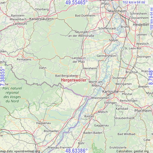
Hergersweiler GPS coordinates[2]
49° 5' 47.004" North, 8° 5' 30.012" East
| Map corner | latitude | longitude |
|---|---|---|
| Upper-left | 49.55465°, | 7.38855° |
| Center: | 49.09639°, | 8.09167° |
| Lower-right: | 48.63386°, | 8.7948° |
| Map W x H: | 102.4×102.4 km | = 63.6×63.6mi |
| max Lat: | 55.01917° ⇑81.8% North |
| Hergersweiler: | 49.09639° |
| min Lat: | ⇓18.2% South 47.40724° |
| min Long | Hergersweiler | max Long |
| 5.92978° | 8.09167° | 14.98853° |
| W 24.4%⇐ | ⇒75.6% E |
Elevation
Elevation of Hergersweiler is 142 m = 466 ft, and this is 107.1 m = 351 ft below average elevation for this country.
| Max E: |
1256 m = 4121 ft | 61.5% |
| Avg. | 249.1 m = 817 ft | |
| Hergersweiler | 142 m = 466 ft | |
Min E: |
-5 m = -16 ft | 38.5% |
See also: Germany elevation on elevation.city.
Geographical zone
Hergersweiler is located in North temperate zone (between Tropic of Cancer and the Arctic Circle). Distance of this North polar circle is 1942.2 km =1206.8 mi to North.| Distance of | km | miles | from Hergersweiler |
|---|---|---|---|
| North Pole | 4548.1 | 2826.1 | to North |
| Arctic Circle | 1942.2 | 1206.8 | to North |
| Tropic Cancer | 2853.1 | 1772.8 | to South |
| Equator | 5459 | 3392.1 | to South |


Nearby cities:
15 places around Hergersweiler: (largest is in red/bold)
• Bad Bergzabern
6.6 km =4.1 mi,  275°
275°
• Barbelroth
1.7 km =1.1 mi, 279°
• Billigheim-Ingenheim
4.5 km =2.8 mi,  358°
358°
• Dierbach
2.5 km =1.6 mi,  225°
225°
• Freckenfeld
3.8 km =2.4 mi,  155°
155°
• Heuchelheim-Klingen
6.1 km =3.8 mi,  333°
333°
• Kapellen-Drusweiler
4.4 km =2.7 mi, 277°
• Minfeld
4.8 km =3 mi,  125°
125°
• Niederhorbach
4.7 km =2.9 mi,  296°
296°
• Niederotterbach
5.2 km =3.2 mi,  219°
219°
• Oberhausen
2.4 km =1.5 mi,  271°
271°
• Rohrbach
5.2 km =3.2 mi,  30°
30°
• Steinweiler
4.5 km =2.8 mi,  52°
52°
• Vollmersweiler
3.6 km =2.2 mi,  196°
196°
• Winden
1.8 km =1.1 mi,  85°
85°
Sources, notices
• [Note1] Compared only with cities in Germany existing in our database
• [Src1] Map data: © OpenStreetMap contributors (CC-BY-SA)
• [Src2] Other city data from geonames.org with taken over terms of usage.
• [Src3] Geographical zone / Annual Mean Temperature by Robert A. Rohde @ Wikipedia
