Steinweiler geodata
Steinweiler (Rheinland-Pfalz) is a seat of a fourth-order administrative division; located in Germany in Europe/Berlin (GMT+2) time zone. With population of 1,843 people, there are 5285 cities with bigger population in this country. Compared to other cities in Germany, 81.5% of cities are located further ↑North; 74.8% of cities are located further →East and 62.9% of cities have higher elevation than Steinweiler. Note1
Administrative division(s):
- Level 1: Rheinland-Pfalz
- Level 3: Landkreis Germersheim
- Level 4: Steinweiler


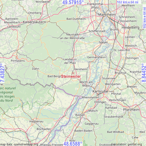
Steinweiler GPS coordinates[2]
49° 7' 15.996" North, 8° 8' 29.004" East
| Map corner | latitude | longitude |
|---|---|---|
| Upper-left | 49.57915°, | 7.43827° |
| Center: | 49.12111°, | 8.14139° |
| Lower-right: | 48.6588°, | 8.84452° |
| Map W x H: | 102.3×102.3 km | = 63.6×63.6mi |
| max Lat: | 55.01917° ⇑81.5% North |
| Steinweiler: | 49.12111° |
| min Lat: | ⇓18.5% South 47.40724° |
| min Long | Steinweiler | max Long |
| 5.92978° | 8.14139° | 14.98853° |
| W 25.2%⇐ | ⇒74.8% E |
Elevation
Elevation of Steinweiler is 133 m = 436 ft, and this is 116.1 m = 381 ft below average elevation for this country.
| Max E: |
1256 m = 4121 ft | 62.9% |
| Avg. | 249.1 m = 817 ft | |
| Steinweiler | 133 m = 436 ft | |
Min E: |
-5 m = -16 ft | 37.1% |
See also: Germany elevation on elevation.city.
Geographical zone
Steinweiler is located in North temperate zone (between Tropic of Cancer and the Arctic Circle). Distance of this North polar circle is 1939.4 km =1205.1 mi to North.| Distance of | km | miles | from Steinweiler |
|---|---|---|---|
| North Pole | 4545.3 | 2824.3 | to North |
| Arctic Circle | 1939.4 | 1205.1 | to North |
| Tropic Cancer | 2855.8 | 1774.5 | to South |
| Equator | 5461.8 | 3393.8 | to South |


Nearby cities:
15 places around Steinweiler: (largest is in red/bold)
• Barbelroth
5.8 km =3.6 mi,  244°
244°
• Billigheim-Ingenheim
4.1 km =2.5 mi,  295°
295°
• Dierbach
7 km =4.3 mi,  230°
230°
• Erlenbach
3.5 km =2.2 mi,  109°
109°
• Freckenfeld
6.6 km =4.1 mi,  197°
197°
• Hergersweiler
4.5 km =2.8 mi, 232°
• Herxheim
5.9 km =3.7 mi,  61°
61°
• Heuchelheim-Klingen
6.8 km =4.2 mi,  293°
293°
• Impflingen
5 km =3.1 mi,  335°
335°
• Insheim
4.1 km =2.5 mi,  5°
5°
• Kandel
5.9 km =3.7 mi,  136°
136°
• Minfeld
5.5 km =3.4 mi,  177°
177°
• Oberhausen
6.6 km =4.1 mi,  246°
246°
• Rohrbach
2 km =1.2 mi,  331°
331°
• Winden
3.1 km =1.9 mi,  214°
214°
Sources, notices
• [Note1] Compared only with cities in Germany existing in our database
• [Src1] Map data: © OpenStreetMap contributors (CC-BY-SA)
• [Src2] Other city data from geonames.org with taken over terms of usage.
• [Src3] Geographical zone / Annual Mean Temperature by Robert A. Rohde @ Wikipedia
