Winden geodata
Winden (Rheinland-Pfalz) is a seat of a fourth-order administrative division; located in Germany in Europe/Berlin (GMT+2) time zone. With population of 1,054 people, there are 6987 cities with bigger population in this country. Compared to other cities in Germany, 81.7% of cities are located further ↑North; 75.1% of cities are located further →East and 61.3% of cities have higher elevation than Winden. Note1


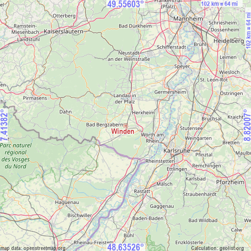
Winden GPS coordinates[2]
49° 5' 52.008" North, 8° 7' 0.984" East
| Map corner | latitude | longitude |
|---|---|---|
| Upper-left | 49.55603°, | 7.41382° |
| Center: | 49.09778°, | 8.11694° |
| Lower-right: | 48.63526°, | 8.82007° |
| Map W x H: | 102.4×102.4 km | = 63.6×63.6mi |
| max Lat: | 55.01917° ⇑81.7% North |
| Winden: | 49.09778° |
| min Lat: | ⇓18.3% South 47.40724° |
| min Long | Winden | max Long |
| 5.92978° | 8.11694° | 14.98853° |
| W 24.9%⇐ | ⇒75.1% E |
Elevation
Elevation of Winden is 143 m = 469 ft, and this is 106.1 m = 348 ft below average elevation for this country.
| Max E: |
1256 m = 4121 ft | 61.3% |
| Avg. | 249.1 m = 817 ft | |
| Winden | 143 m = 469 ft | |
Min E: |
-5 m = -16 ft | 38.7% |
See also: Germany elevation on elevation.city.
Geographical zone
Winden is located in North temperate zone (between Tropic of Cancer and the Arctic Circle). Distance of this North polar circle is 1942 km =1206.7 mi to North.| Distance of | km | miles | from Winden |
|---|---|---|---|
| North Pole | 4547.9 | 2825.9 | to North |
| Arctic Circle | 1942 | 1206.7 | to North |
| Tropic Cancer | 2853.2 | 1772.9 | to South |
| Equator | 5459.2 | 3392.2 | to South |


Nearby cities:
15 places around Winden: (largest is in red/bold)
• Barbelroth
3.5 km =2.2 mi,  272°
272°
• Billigheim-Ingenheim
4.7 km =2.9 mi,  336°
336°
• Dierbach
4.1 km =2.5 mi,  242°
242°
• Erlenbach
5.3 km =3.3 mi,  74°
74°
• Freckenfeld
3.7 km =2.3 mi,  183°
183°
• Hergersweiler
1.8 km =1.1 mi, 265°
• Kandel
6.1 km =3.8 mi,  105°
105°
• Kapellen-Drusweiler
6.3 km =3.9 mi, 273°
• Minfeld
3.6 km =2.2 mi,  144°
144°
• Niederhorbach
6.3 km =3.9 mi,  287°
287°
• Niederotterbach
6.7 km =4.2 mi,  231°
231°
• Oberhausen
4.3 km =2.7 mi, 268°
• Rohrbach
4.4 km =2.7 mi,  11°
11°
• Steinweiler
3.1 km =1.9 mi,  34°
34°
• Vollmersweiler
4.7 km =2.9 mi,  218°
218°
Sources, notices
• [Note1] Compared only with cities in Germany existing in our database
• [Src1] Map data: © OpenStreetMap contributors (CC-BY-SA)
• [Src2] Other city data from geonames.org with taken over terms of usage.
• [Src3] Geographical zone / Annual Mean Temperature by Robert A. Rohde @ Wikipedia
