Rohrbach geodata
Rohrbach (Rheinland-Pfalz) is a seat of a fourth-order administrative division; located in Germany in Europe/Berlin (GMT+2) time zone. With population of 1,699 people, there are 5514 cities with bigger population in this country. Compared to other cities in Germany, 81.3% of cities are located further ↑North; 75% of cities are located further →East and 62.5% of cities have higher elevation than Rohrbach. Note1
Administrative division(s):
- Level 1: Rheinland-Pfalz
- Level 3: Landkreis Südliche Weinstraße
- Level 4: Rohrbach


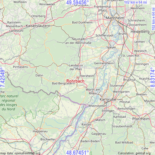
Rohrbach GPS coordinates[2]
49° 8' 12.012" North, 8° 7' 42.996" East
| Map corner | latitude | longitude |
|---|---|---|
| Upper-left | 49.59456°, | 7.42549° |
| Center: | 49.13667°, | 8.12861° |
| Lower-right: | 48.67451°, | 8.83174° |
| Map W x H: | 102.3×102.3 km | = 63.6×63.6mi |
| max Lat: | 55.01917° ⇑81.3% North |
| Rohrbach: | 49.13667° |
| min Lat: | ⇓18.7% South 47.40724° |
| min Long | Rohrbach | max Long |
| 5.92978° | 8.12861° | 14.98853° |
| W 25%⇐ | ⇒75% E |
Elevation
Elevation of Rohrbach is 135 m = 443 ft, and this is 114.1 m = 374 ft below average elevation for this country.
| Max E: |
1256 m = 4121 ft | 62.5% |
| Avg. | 249.1 m = 817 ft | |
| Rohrbach | 135 m = 443 ft | |
Min E: |
-5 m = -16 ft | 37.5% |
See also: Germany elevation on elevation.city.
Geographical zone
Rohrbach is located in North temperate zone (between Tropic of Cancer and the Arctic Circle). Distance of this North polar circle is 1937.7 km =1204 mi to North.| Distance of | km | miles | from Rohrbach |
|---|---|---|---|
| North Pole | 4543.6 | 2823.3 | to North |
| Arctic Circle | 1937.7 | 1204 | to North |
| Tropic Cancer | 2857.6 | 1775.6 | to South |
| Equator | 5463.5 | 3394.9 | to South |


Nearby cities:
15 places around Rohrbach: (largest is in red/bold)
• Barbelroth
6 km =3.7 mi,  225°
225°
• Billigheim-Ingenheim
2.8 km =1.7 mi,  270°
270°
• Erlenbach
5.1 km =3.2 mi,  124°
124°
• Göcklingen
6.9 km =4.3 mi,  293°
293°
• Hergersweiler
5.2 km =3.2 mi,  210°
210°
• Herxheim
6.3 km =3.9 mi,  80°
80°
• Heuchelheim-Klingen
5.4 km =3.4 mi,  280°
280°
• Impflingen
3.1 km =1.9 mi,  338°
338°
• Insheim
2.7 km =1.7 mi,  29°
29°
• Landau in der Pfalz
6.9 km =4.3 mi,  352°
352°
• Minfeld
7.3 km =4.5 mi,  170°
170°
• Niederhorbach
7.3 km =4.5 mi,  250°
250°
• Oberhausen
6.8 km =4.2 mi, 229°
• Steinweiler
2 km =1.2 mi,  151°
151°
• Winden
4.4 km =2.7 mi,  191°
191°
Sources, notices
• [Note1] Compared only with cities in Germany existing in our database
• [Src1] Map data: © OpenStreetMap contributors (CC-BY-SA)
• [Src2] Other city data from geonames.org with taken over terms of usage.
• [Src3] Geographical zone / Annual Mean Temperature by Robert A. Rohde @ Wikipedia
