Hendungen geodata
Hendungen (Bavaria) is a seat of a fourth-order administrative division; located in Germany in Europe/Berlin (GMT+2) time zone. With population of 1,015 people, there are 7131 cities with bigger population in this country. Compared to other cities in Germany, 54.8% of cities are located further ↑North; 56.4% of cities are located further ←West and 62.8% of cities have lower elevation than Hendungen. Note1
Administrative division(s):
- Level 1: Bavaria
- Level 2: Regierungsbezirk Unterfranken
- Level 3: Landkreis Rhön-Grabfeld
- Level 4: Hendungen


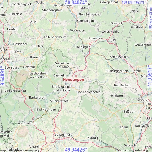
Hendungen GPS coordinates[2]
50° 23' 40.632" North, 10° 21' 7.344" East
| Map corner | latitude | longitude |
|---|---|---|
| Upper-left | 50.84074°, | 9.64891° |
| Center: | 50.39462°, | 10.35204° |
| Lower-right: | 49.94426°, | 11.05517° |
| Map W x H: | 99.7×99.7 km | = 62×62mi |
| max Lat: | 55.01917° ⇑54.8% North |
| Hendungen: | 50.39462° |
| min Lat: | ⇓45.2% South 47.40724° |
| min Long | Hendungen | max Long |
| 5.92978° | 10.35204° | 14.98853° |
| W 56.4%⇐ | ⇒43.6% E |
Elevation
Elevation of Hendungen is 307 m = 1007 ft, and this is 57.9 m = 190 ft above average elevation for this country.
| Max E: |
1256 m = 4121 ft | 37.2% |
| Hendungen | 307 m 1007 ft | |
| Avg. | 249.1 m = 817 ft | |
Min E: |
-5 m = -16 ft | 62.8% |
See also: Germany elevation on elevation.city.
Geographical zone
Hendungen is located in North temperate zone (between Tropic of Cancer and the Arctic Circle). Distance of this North polar circle is 1797.8 km =1117.1 mi to North.| Distance of | km | miles | from Hendungen |
|---|---|---|---|
| North Pole | 4403.7 | 2736.3 | to North |
| Arctic Circle | 1797.8 | 1117.1 | to North |
| Tropic Cancer | 2997.4 | 1862.5 | to South |
| Equator | 5603.4 | 3481.8 | to South |


Nearby cities:
15 places around Hendungen: (largest is in red/bold)
• Aubstadt
8.9 km =5.5 mi,  139°
139°
• Behrungen
4.8 km =3 mi,  67°
67°
• Bibra
10.4 km =6.5 mi,  36°
36°
• Heustreu
7.8 km =4.8 mi,  235°
235°
• Hollstadt
6.2 km =3.9 mi,  216°
216°
• Höchheim
7.6 km =4.7 mi,  114°
114°
• Mellrichstadt
5.1 km =3.2 mi,  317°
317°
• Oberstreu
4.7 km =2.9 mi,  282°
282°
• Queienfeld
9.6 km =6 mi,  49°
49°
• Rödelmaier
9.9 km =6.2 mi,  212°
212°
• Saal an der Saale
8.7 km =5.4 mi,  177°
177°
• Stockheim
9.1 km =5.7 mi, 322°
• Unsleben
7.2 km =4.5 mi,  256°
256°
• Wollbach
9 km =5.6 mi,  249°
249°
• Wülfershausen
7 km =4.3 mi,  186°
186°
Sources, notices
• [Note1] Compared only with cities in Germany existing in our database
• [Src1] Map data: © OpenStreetMap contributors (CC-BY-SA)
• [Src2] Other city data from geonames.org with taken over terms of usage.
• [Src3] Geographical zone / Annual Mean Temperature by Robert A. Rohde @ Wikipedia
