Mellrichstadt geodata
Mellrichstadt (Bavaria) is a populated place; located in Germany in Europe/Berlin (GMT+2) time zone. With population of 6,254 people, there are 2384 cities with bigger population in this country. Compared to other cities in Germany, 54.1% of cities are located further ↑North; 55.5% of cities are located further ←West and 58.3% of cities have lower elevation than Mellrichstadt. Note1
Administrative division(s):
- Level 1: Bavaria
- Level 2: Regierungsbezirk Unterfranken
- Level 3: Landkreis Rhön-Grabfeld
- Level 4: Mellrichstadt


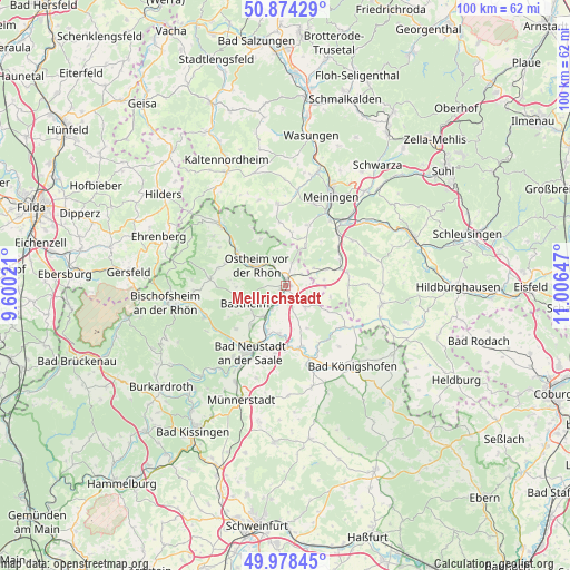
Mellrichstadt GPS coordinates[2]
50° 25' 42.564" North, 10° 18' 12.024" East
| Map corner | latitude | longitude |
|---|---|---|
| Upper-left | 50.87429°, | 9.60021° |
| Center: | 50.42849°, | 10.30334° |
| Lower-right: | 49.97845°, | 11.00647° |
| Map W x H: | 99.6×99.6 km | = 61.9×61.9mi |
| max Lat: | 55.01917° ⇑54.1% North |
| Mellrichstadt: | 50.42849° |
| min Lat: | ⇓45.9% South 47.40724° |
| min Long | Mellrichstadt | max Long |
| 5.92978° | 10.30334° | 14.98853° |
| W 55.5%⇐ | ⇒44.5% E |
Elevation
Elevation of Mellrichstadt is 280 m = 919 ft, and this is 30.9 m = 101 ft above average elevation for this country.
| Max E: |
1256 m = 4121 ft | 41.7% |
| Mellrichstadt | 280 m 919 ft | |
| Avg. | 249.1 m = 817 ft | |
Min E: |
-5 m = -16 ft | 58.3% |
See also: Germany elevation on elevation.city.
Geographical zone
Mellrichstadt is located in North temperate zone (between Tropic of Cancer and the Arctic Circle). Distance of this North polar circle is 1794.1 km =1114.8 mi to North.| Distance of | km | miles | from Mellrichstadt |
|---|---|---|---|
| North Pole | 4399.9 | 2734 | to North |
| Arctic Circle | 1794.1 | 1114.8 | to North |
| Tropic Cancer | 3001.2 | 1864.9 | to South |
| Equator | 5607.1 | 3484.1 | to South |


Nearby cities:
15 places around Mellrichstadt: (largest is in red/bold)
• Bastheim
7.7 km =4.8 mi,  246°
246°
• Behrungen
8.1 km =5 mi,  103°
103°
• Bibra
10.6 km =6.6 mi,  64°
64°
• Hendungen
5.1 km =3.2 mi,  137°
137°
• Henneberg
8 km =5 mi,  27°
27°
• Heustreu
8.7 km =5.4 mi,  200°
200°
• Hollstadt
8.7 km =5.4 mi,  181°
181°
• Oberstreu
3 km =1.9 mi, 201°
• Ostheim vor der Rhön
6.2 km =3.9 mi,  304°
304°
• Queienfeld
11 km =6.8 mi,  77°
77°
• Stockheim
4.1 km =2.5 mi,  328°
328°
• Unsleben
6.5 km =4 mi,  213°
213°
• Willmars
8.8 km =5.5 mi, 334°
• Wollbach
8.5 km =5.3 mi,  215°
215°
• Wölfershausen
11 km =6.8 mi, 56°
Sources, notices
• [Note1] Compared only with cities in Germany existing in our database
• [Src1] Map data: © OpenStreetMap contributors (CC-BY-SA)
• [Src2] Other city data from geonames.org with taken over terms of usage.
• [Src3] Geographical zone / Annual Mean Temperature by Robert A. Rohde @ Wikipedia
