Behrungen geodata
Behrungen (Thuringia) is a populated place; located in Germany in Europe/Berlin (GMT+2) time zone. With population of 686 people, there are 8384 cities with bigger population in this country. Compared to other cities in Germany, 54.4% of cities are located further ↑North; 57.3% of cities are located further ←West and 67.2% of cities have lower elevation than Behrungen. Note1
Administrative division(s):
- Level 1: Thuringia
- Level 3: Landkreis Schmalkalden-Meiningen
- Level 4: Grabfeld


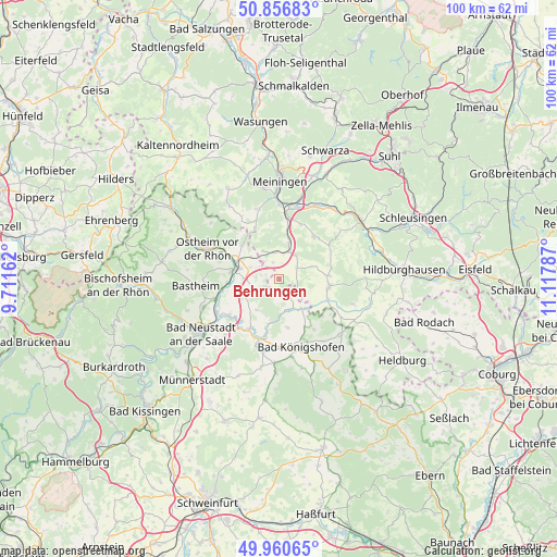
Behrungen GPS coordinates[2]
50° 24' 39.096" North, 10° 24' 53.064" East
| Map corner | latitude | longitude |
|---|---|---|
| Upper-left | 50.85683°, | 9.71162° |
| Center: | 50.41086°, | 10.41474° |
| Lower-right: | 49.96065°, | 11.11787° |
| Map W x H: | 99.6×99.6 km | = 61.9×61.9mi |
| max Lat: | 55.01917° ⇑54.4% North |
| Behrungen: | 50.41086° |
| min Lat: | ⇓45.6% South 47.40724° |
| min Long | Behrungen | max Long |
| 5.92978° | 10.41474° | 14.98853° |
| W 57.3%⇐ | ⇒42.7% E |
Elevation
Elevation of Behrungen is 337 m = 1106 ft, and this is 87.9 m = 288 ft above average elevation for this country.
| Max E: |
1256 m = 4121 ft | 32.8% |
| Behrungen | 337 m 1106 ft | |
| Avg. | 249.1 m = 817 ft | |
Min E: |
-5 m = -16 ft | 67.2% |
See also: Germany elevation on elevation.city.
Geographical zone
Behrungen is located in North temperate zone (between Tropic of Cancer and the Arctic Circle). Distance of this North polar circle is 1796 km =1116 mi to North.| Distance of | km | miles | from Behrungen |
|---|---|---|---|
| North Pole | 4401.9 | 2735.2 | to North |
| Arctic Circle | 1796 | 1116 | to North |
| Tropic Cancer | 2999.2 | 1863.6 | to South |
| Equator | 5605.2 | 3482.9 | to South |


Nearby cities:
15 places around Behrungen: (largest is in red/bold)
• Aubstadt
8.7 km =5.4 mi,  171°
171°
• Bibra
6.8 km =4.2 mi,  14°
14°
• Exdorf
10.4 km =6.5 mi,  60°
60°
• Hendungen
4.8 km =3 mi,  247°
247°
• Henneberg
10 km =6.2 mi,  334°
334°
• Herbstadt
10.5 km =6.5 mi,  144°
144°
• Höchheim
5.5 km =3.4 mi,  153°
153°
• Jüchsen
9.8 km =6.1 mi,  38°
38°
• Mellrichstadt
8.1 km =5 mi,  283°
283°
• Milz
9.5 km =5.9 mi,  113°
113°
• Oberstreu
9 km =5.6 mi,  264°
264°
• Queienfeld
5.3 km =3.3 mi,  33°
33°
• Römhild
8.9 km =5.5 mi,  100°
100°
• Wölfershausen
8.2 km =5.1 mi, 9°
• Wülfershausen
10.2 km =6.3 mi,  210°
210°
Sources, notices
• [Note1] Compared only with cities in Germany existing in our database
• [Src1] Map data: © OpenStreetMap contributors (CC-BY-SA)
• [Src2] Other city data from geonames.org with taken over terms of usage.
• [Src3] Geographical zone / Annual Mean Temperature by Robert A. Rohde @ Wikipedia
