Brest geodata
Brest (Lower Saxony) is a seat of a fourth-order administrative division; located in Germany in Europe/Berlin (GMT+2) time zone. With population of 827 people, there are 7791 cities with bigger population in this country. Compared to other cities in Germany, 85% of cities are located further ↓South; 59.6% of cities are located further →East and 87% of cities have higher elevation than Brest. Note1


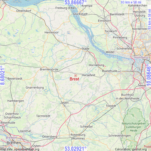
Brest GPS coordinates[2]
53° 27' 0" North, 9° 22' 59.988" East
| Map corner | latitude | longitude |
|---|---|---|
| Upper-left | 53.86667°, | 8.68021° |
| Center: | 53.45°, | 9.38333° |
| Lower-right: | 53.02921°, | 10.08646° |
| Map W x H: | 93.1×93.1 km | = 57.8×57.8mi |
| max Lat: | 55.01917° ⇑15% North |
| Brest: | 53.45° |
| min Lat: | ⇓85% South 47.40724° |
| min Long | Brest | max Long |
| 5.92978° | 9.38333° | 14.98853° |
| W 40.4%⇐ | ⇒59.6% E |
Elevation
Elevation of Brest is 30 m = 98 ft, and this is 219.1 m = 719 ft below average elevation for this country.
| Max E: |
1256 m = 4121 ft | 87% |
| Avg. | 249.1 m = 817 ft | |
| Brest | 30 m = 98 ft | |
Min E: |
-5 m = -16 ft | 13% |
See also: Germany elevation on elevation.city.
Geographical zone
Brest is located in North temperate zone (between Tropic of Cancer and the Arctic Circle). Distance of this North polar circle is 1458.1 km =906 mi to North.| Distance of | km | miles | from Brest |
|---|---|---|---|
| North Pole | 4064 | 2525.3 | to North |
| Arctic Circle | 1458.1 | 906 | to North |
| Tropic Cancer | 3337.2 | 2073.6 | to South |
| Equator | 5943.1 | 3692.9 | to South |


Nearby cities:
15 places around Brest: (largest is in red/bold)
• Ahlerstedt
7.1 km =4.4 mi,  141°
141°
• Anderlingen
9.9 km =6.2 mi,  212°
212°
• Bargstedt
4.8 km =3 mi,  67°
67°
• Bliedersdorf
12.7 km =7.9 mi, 73°
• Deinste
9.7 km =6 mi,  24°
24°
• Deinstedt
10.6 km =6.6 mi,  249°
249°
• Dollern
14.4 km =8.9 mi,  49°
49°
• Farven
4.8 km =3 mi, 247°
• Harsefeld
7.9 km =4.9 mi,  86°
86°
• Heinböckel
14.4 km =8.9 mi,  344°
344°
• Horneburg
14.2 km =8.8 mi,  63°
63°
• Kutenholz
5.4 km =3.4 mi,  310°
310°
• Nottensdorf
14.8 km =9.2 mi,  75°
75°
• Selsingen
14.2 km =8.8 mi,  232°
232°
• Wohnste
14.9 km =9.3 mi, 138°
Sources, notices
• [Note1] Compared only with cities in Germany existing in our database
• [Src1] Map data: © OpenStreetMap contributors (CC-BY-SA)
• [Src2] Other city data from geonames.org with taken over terms of usage.
• [Src3] Geographical zone / Annual Mean Temperature by Robert A. Rohde @ Wikipedia
