Kutenholz geodata
Kutenholz (Lower Saxony) is a seat of a fourth-order administrative division; located in Germany in Europe/Berlin (GMT+2) time zone. With population of 4,964 people, there are 2847 cities with bigger population in this country. Compared to other cities in Germany, 85.3% of cities are located further ↓South; 60.4% of cities are located further →East and 89.3% of cities have higher elevation than Kutenholz. Note1


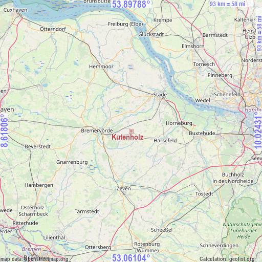
Kutenholz GPS coordinates[2]
53° 28' 53.472" North, 9° 19' 16.248" East
| Map corner | latitude | longitude |
|---|---|---|
| Upper-left | 53.89788°, | 8.61806° |
| Center: | 53.48152°, | 9.32118° |
| Lower-right: | 53.06104°, | 10.02431° |
| Map W x H: | 93×93 km | = 57.8×57.8mi |
| max Lat: | 55.01917° ⇑14.7% North |
| Kutenholz: | 53.48152° |
| min Lat: | ⇓85.3% South 47.40724° |
| min Long | Kutenholz | max Long |
| 5.92978° | 9.32118° | 14.98853° |
| W 39.6%⇐ | ⇒60.4% E |
Elevation
Elevation of Kutenholz is 23 m = 75 ft, and this is 226.1 m = 742 ft below average elevation for this country.
| Max E: |
1256 m = 4121 ft | 89.3% |
| Avg. | 249.1 m = 817 ft | |
| Kutenholz | 23 m = 75 ft | |
Min E: |
-5 m = -16 ft | 10.7% |
See also: Germany elevation on elevation.city.
Geographical zone
Kutenholz is located in North temperate zone (between Tropic of Cancer and the Arctic Circle). Distance of this North polar circle is 1454.6 km =903.8 mi to North.| Distance of | km | miles | from Kutenholz |
|---|---|---|---|
| North Pole | 4060.5 | 2523.1 | to North |
| Arctic Circle | 1454.6 | 903.8 | to North |
| Tropic Cancer | 3340.7 | 2075.8 | to South |
| Equator | 5946.6 | 3695 | to South |


Nearby cities:
15 places around Kutenholz: (largest is in red/bold)
• Ahlerstedt
12.4 km =7.7 mi,  136°
136°
• Anderlingen
12 km =7.5 mi,  185°
185°
• Bargstedt
8.7 km =5.4 mi,  100°
100°
• Bei der Höhne
14.3 km =8.9 mi,  284°
284°
• Bremervörde
11.8 km =7.3 mi,  271°
271°
• Brest
5.4 km =3.4 mi,  130°
130°
• Deinste
9.7 km =6 mi,  56°
56°
• Deinstedt
9.3 km =5.8 mi,  218°
218°
• Düdenbüttel
12.3 km =7.6 mi,  8°
8°
• Estorf
13.1 km =8.1 mi,  323°
323°
• Farven
5.4 km =3.4 mi,  183°
183°
• Harsefeld
12.4 km =7.7 mi, 104°
• Heinböckel
10.4 km =6.5 mi,  1°
1°
• Oldendorf
12.3 km =7.6 mi,  337°
337°
• Selsingen
14 km =8.7 mi,  210°
210°
Sources, notices
• [Note1] Compared only with cities in Germany existing in our database
• [Src1] Map data: © OpenStreetMap contributors (CC-BY-SA)
• [Src2] Other city data from geonames.org with taken over terms of usage.
• [Src3] Geographical zone / Annual Mean Temperature by Robert A. Rohde @ Wikipedia
