Heerstedt geodata
Heerstedt (Lower Saxony) is a populated place; located in Germany in Europe/Berlin (GMT+2) time zone. With population of 509 people, there are 9330 cities with bigger population in this country. Compared to other cities in Germany, 85.1% of cities are located further ↓South; 68.4% of cities are located further →East and 94.3% of cities have higher elevation than Heerstedt. Note1


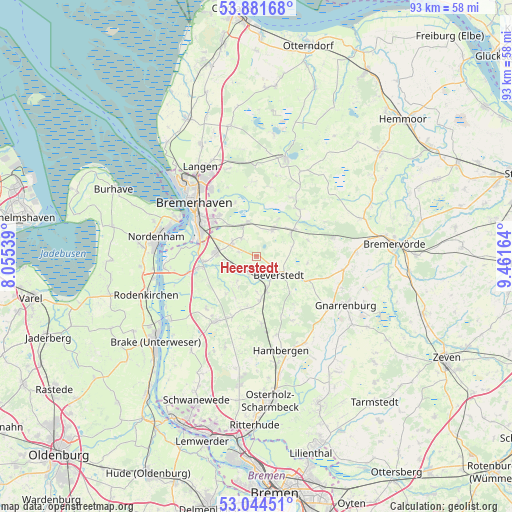
Heerstedt GPS coordinates[2]
53° 27' 54.576" North, 8° 45' 30.636" East
| Map corner | latitude | longitude |
|---|---|---|
| Upper-left | 53.88168°, | 8.05539° |
| Center: | 53.46516°, | 8.75851° |
| Lower-right: | 53.04451°, | 9.46164° |
| Map W x H: | 93.1×93.1 km | = 57.8×57.8mi |
| max Lat: | 55.01917° ⇑14.9% North |
| Heerstedt: | 53.46516° |
| min Lat: | ⇓85.1% South 47.40724° |
| min Long | Heerstedt | max Long |
| 5.92978° | 8.75851° | 14.98853° |
| W 31.6%⇐ | ⇒68.4% E |
Elevation
Elevation of Heerstedt is 10 m = 33 ft, and this is 239.1 m = 784 ft below average elevation for this country.
| Max E: |
1256 m = 4121 ft | 94.3% |
| Avg. | 249.1 m = 817 ft | |
| Heerstedt | 10 m = 33 ft | |
Min E: |
-5 m = -16 ft | 5.7% |
See also: Germany elevation on elevation.city.
Geographical zone
Heerstedt is located in North temperate zone (between Tropic of Cancer and the Arctic Circle). Distance of this North polar circle is 1456.4 km =905 mi to North.| Distance of | km | miles | from Heerstedt |
|---|---|---|---|
| North Pole | 4062.3 | 2524.2 | to North |
| Arctic Circle | 1456.4 | 905 | to North |
| Tropic Cancer | 3338.8 | 2074.6 | to South |
| Equator | 5944.8 | 3693.9 | to South |


Nearby cities:
15 places around Heerstedt: (largest is in red/bold)
• Axstedt
12.3 km =7.6 mi,  174°
174°
• Beverstedt
5.3 km =3.3 mi,  130°
130°
• Bokel
8 km =5 mi,  175°
175°
• Bramstedt
11.9 km =7.4 mi,  202°
202°
• Driftsethe
13.1 km =8.1 mi,  225°
225°
• Frelsdorf
9.7 km =6 mi,  72°
72°
• Hollen
5.7 km =3.5 mi,  218°
218°
• Kirchwistedt
9.9 km =6.2 mi,  117°
117°
• Köhlen
11.4 km =7.1 mi,  42°
42°
• Kührstedt
12.8 km =8 mi,  12°
12°
• Loxstedt
7.2 km =4.5 mi,  271°
271°
• Lunestedt
3.2 km =2 mi,  187°
187°
• Ringstedt
12.2 km =7.6 mi,  29°
29°
• Schiffdorf
10.4 km =6.5 mi,  316°
316°
• Stinstedt
3.4 km =2.1 mi,  285°
285°
Sources, notices
• [Note1] Compared only with cities in Germany existing in our database
• [Src1] Map data: © OpenStreetMap contributors (CC-BY-SA)
• [Src2] Other city data from geonames.org with taken over terms of usage.
• [Src3] Geographical zone / Annual Mean Temperature by Robert A. Rohde @ Wikipedia
