Bokel geodata
Bokel (Lower Saxony) is a populated place; located in Germany in Europe/Berlin (GMT+2) time zone. With population of 2,680 people, there are 4249 cities with bigger population in this country. Compared to other cities in Germany, 84.5% of cities are located further ↓South; 68.3% of cities are located further →East and 93.1% of cities have higher elevation than Bokel. Note1


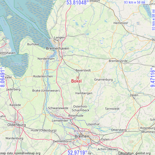
Bokel GPS coordinates[2]
53° 23' 35.736" North, 8° 46' 4.908" East
| Map corner | latitude | longitude |
|---|---|---|
| Upper-left | 53.81048°, | 8.06491° |
| Center: | 53.39326°, | 8.76803° |
| Lower-right: | 52.9719°, | 9.47116° |
| Map W x H: | 93.2×93.2 km | = 57.9×57.9mi |
| max Lat: | 55.01917° ⇑15.5% North |
| Bokel: | 53.39326° |
| min Lat: | ⇓84.5% South 47.40724° |
| min Long | Bokel | max Long |
| 5.92978° | 8.76803° | 14.98853° |
| W 31.7%⇐ | ⇒68.3% E |
Elevation
Elevation of Bokel is 13 m = 43 ft, and this is 236.1 m = 775 ft below average elevation for this country.
| Max E: |
1256 m = 4121 ft | 93.1% |
| Avg. | 249.1 m = 817 ft | |
| Bokel | 13 m = 43 ft | |
Min E: |
-5 m = -16 ft | 6.9% |
See also: Germany elevation on elevation.city.
Geographical zone
Bokel is located in North temperate zone (between Tropic of Cancer and the Arctic Circle). Distance of this North polar circle is 1464.4 km =909.9 mi to North.| Distance of | km | miles | from Bokel |
|---|---|---|---|
| North Pole | 4070.3 | 2529.2 | to North |
| Arctic Circle | 1464.4 | 909.9 | to North |
| Tropic Cancer | 3330.9 | 2069.7 | to South |
| Equator | 5936.8 | 3689 | to South |


Nearby cities:
15 places around Bokel: (largest is in red/bold)
• Axstedt
4.3 km =2.7 mi,  173°
173°
• Beverstedt
5.7 km =3.5 mi,  36°
36°
• Bramstedt
6 km =3.7 mi,  239°
239°
• Driftsethe
10.1 km =6.3 mi,  263°
263°
• Hagen im Bremischen
9.2 km =5.7 mi, 244°
• Hambergen
10.2 km =6.3 mi,  158°
158°
• Heerstedt
8 km =5 mi,  355°
355°
• Hollen
5.5 km =3.4 mi,  309°
309°
• Kirchwistedt
8.8 km =5.5 mi,  67°
67°
• Loxstedt
11.3 km =7 mi,  316°
316°
• Lunestedt
4.9 km =3 mi,  347°
347°
• Lübberstedt
7 km =4.3 mi, 162°
• Stinstedt
9.7 km =6 mi,  336°
336°
• Vollersode
11.9 km =7.4 mi,  124°
124°
• Wulsbüttel
10.9 km =6.8 mi,  218°
218°
Sources, notices
• [Note1] Compared only with cities in Germany existing in our database
• [Src1] Map data: © OpenStreetMap contributors (CC-BY-SA)
• [Src2] Other city data from geonames.org with taken over terms of usage.
• [Src3] Geographical zone / Annual Mean Temperature by Robert A. Rohde @ Wikipedia
