Stinstedt geodata
Stinstedt (Lower Saxony) is a populated place; located in Germany in Europe/Berlin (GMT+2) time zone. With population of 594 people, there are 8858 cities with bigger population in this country. Compared to other cities in Germany, 85.2% of cities are located further ↓South; 68.9% of cities are located further →East and 95.6% of cities have higher elevation than Stinstedt. Note1


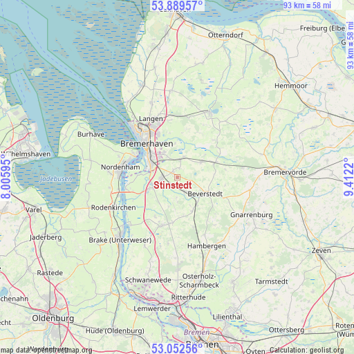
Stinstedt GPS coordinates[2]
53° 28' 23.268" North, 8° 42' 32.652" East
| Map corner | latitude | longitude |
|---|---|---|
| Upper-left | 53.88957°, | 8.00595° |
| Center: | 53.47313°, | 8.70907° |
| Lower-right: | 53.05256°, | 9.4122° |
| Map W x H: | 93.1×93.1 km | = 57.8×57.8mi |
| max Lat: | 55.01917° ⇑14.8% North |
| Stinstedt: | 53.47313° |
| min Lat: | ⇓85.2% South 47.40724° |
| min Long | Stinstedt | max Long |
| 5.92978° | 8.70907° | 14.98853° |
| W 31.1%⇐ | ⇒68.9% E |
Elevation
Elevation of Stinstedt is 7 m = 23 ft, and this is 242.1 m = 794 ft below average elevation for this country.
| Max E: |
1256 m = 4121 ft | 95.6% |
| Avg. | 249.1 m = 817 ft | |
| Stinstedt | 7 m = 23 ft | |
Min E: |
-5 m = -16 ft | 4.4% |
See also: Germany elevation on elevation.city.
Geographical zone
Stinstedt is located in North temperate zone (between Tropic of Cancer and the Arctic Circle). Distance of this North polar circle is 1455.5 km =904.4 mi to North.| Distance of | km | miles | from Stinstedt |
|---|---|---|---|
| North Pole | 4061.4 | 2523.6 | to North |
| Arctic Circle | 1455.5 | 904.4 | to North |
| Tropic Cancer | 3339.7 | 2075.2 | to South |
| Equator | 5945.7 | 3694.5 | to South |


Nearby cities:
15 places around Stinstedt: (largest is in red/bold)
• Beverstedt
8.5 km =5.3 mi,  120°
120°
• Bokel
9.7 km =6 mi,  156°
156°
• Bramstedt
12 km =7.5 mi,  186°
186°
• Bremerhaven
12.2 km =7.6 mi,  314°
314°
• Driftsethe
11.7 km =7.3 mi,  211°
211°
• Elmlohe
12.8 km =8 mi,  9°
9°
• Frelsdorf
12.7 km =7.9 mi,  80°
80°
• Heerstedt
3.4 km =2.1 mi,  105°
105°
• Hollen
5.4 km =3.4 mi,  183°
183°
• Kirchwistedt
13.2 km =8.2 mi, 114°
• Köhlen
13.3 km =8.3 mi,  55°
55°
• Kührstedt
13.1 km =8.1 mi,  27°
27°
• Loxstedt
4 km =2.5 mi,  259°
259°
• Lunestedt
5 km =3.1 mi,  145°
145°
• Schiffdorf
7.8 km =4.8 mi,  329°
329°
Sources, notices
• [Note1] Compared only with cities in Germany existing in our database
• [Src1] Map data: © OpenStreetMap contributors (CC-BY-SA)
• [Src2] Other city data from geonames.org with taken over terms of usage.
• [Src3] Geographical zone / Annual Mean Temperature by Robert A. Rohde @ Wikipedia
