Uehrde geodata
Uehrde (Lower Saxony) is a seat of a fourth-order administrative division; located in Germany in Europe/Berlin (GMT+2) time zone. With population of 1,041 people, there are 7046 cities with bigger population in this country. Compared to other cities in Germany, 73% of cities are located further ↓South; 63.5% of cities are located further ←West and 66% of cities have higher elevation than Uehrde. Note1


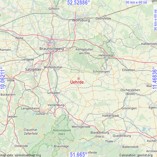
Uehrde GPS coordinates[2]
52° 5' 56.472" North, 10° 45' 54.828" East
| Map corner | latitude | longitude |
|---|---|---|
| Upper-left | 52.52886°, | 10.06211° |
| Center: | 52.09902°, | 10.76523° |
| Lower-right: | 51.665°, | 11.46836° |
| Map W x H: | 96.1×96.1 km | = 59.7×59.7mi |
| max Lat: | 55.01917° ⇑27% North |
| Uehrde: | 52.09902° |
| min Lat: | ⇓73% South 47.40724° |
| min Long | Uehrde | max Long |
| 5.92978° | 10.76523° | 14.98853° |
| W 63.5%⇐ | ⇒36.5% E |
Elevation
Elevation of Uehrde is 114 m = 374 ft, and this is 135.1 m = 443 ft below average elevation for this country.
| Max E: |
1256 m = 4121 ft | 66% |
| Avg. | 249.1 m = 817 ft | |
| Uehrde | 114 m = 374 ft | |
Min E: |
-5 m = -16 ft | 34% |
See also: Germany elevation on elevation.city.
Geographical zone
Uehrde is located in North temperate zone (between Tropic of Cancer and the Arctic Circle). Distance of this North polar circle is 1608.3 km =999.4 mi to North.| Distance of | km | miles | from Uehrde |
|---|---|---|---|
| North Pole | 4214.2 | 2618.6 | to North |
| Arctic Circle | 1608.3 | 999.4 | to North |
| Tropic Cancer | 3186.9 | 1980.2 | to South |
| Equator | 5792.9 | 3599.5 | to South |


Nearby cities:
15 places around Uehrde: (largest is in red/bold)
• Beierstedt
6.9 km =4.3 mi,  113°
113°
• Dahlum
6.9 km =4.3 mi,  56°
56°
• Dettum
10.5 km =6.5 mi,  320°
320°
• Gevensleben
4.6 km =2.9 mi,  122°
122°
• Hedeper
6.7 km =4.2 mi,  237°
237°
• Ingeleben
7.4 km =4.6 mi,  83°
83°
• Jerxheim
9.3 km =5.8 mi,  101°
101°
• Kneitlingen
8.4 km =5.2 mi,  358°
358°
• Remlingen
6.4 km =4 mi,  284°
284°
• Roklum
4 km =2.5 mi,  204°
204°
• Schöppenstedt
4.9 km =3 mi,  7°
7°
• Semmenstedt
4.7 km =2.9 mi,  262°
262°
• Vahlberg
5.1 km =3.2 mi, 319°
• Winnigstedt
3.6 km =2.2 mi,  176°
176°
• Wittmar
9.2 km =5.7 mi,  291°
291°
Sources, notices
• [Note1] Compared only with cities in Germany existing in our database
• [Src1] Map data: © OpenStreetMap contributors (CC-BY-SA)
• [Src2] Other city data from geonames.org with taken over terms of usage.
• [Src3] Geographical zone / Annual Mean Temperature by Robert A. Rohde @ Wikipedia
