Vahlberg geodata
Vahlberg (Lower Saxony) is a seat of a fourth-order administrative division; located in Germany in Europe/Berlin (GMT+2) time zone. With population of 855 people, there are 7683 cities with bigger population in this country. Compared to other cities in Germany, 73.3% of cities are located further ↓South; 62.7% of cities are located further ←West and 64.1% of cities have higher elevation than Vahlberg. Note1


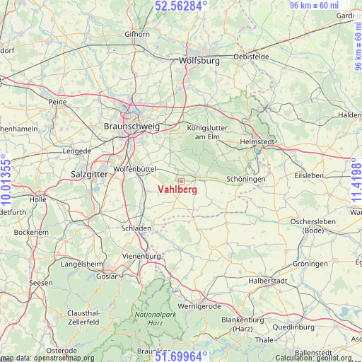
Vahlberg GPS coordinates[2]
52° 7' 59.988" North, 10° 43' 0.012" East
| Map corner | latitude | longitude |
|---|---|---|
| Upper-left | 52.56284°, | 10.01355° |
| Center: | 52.13333°, | 10.71667° |
| Lower-right: | 51.69964°, | 11.4198° |
| Map W x H: | 96×96 km | = 59.7×59.7mi |
| max Lat: | 55.01917° ⇑26.7% North |
| Vahlberg: | 52.13333° |
| min Lat: | ⇓73.3% South 47.40724° |
| min Long | Vahlberg | max Long |
| 5.92978° | 10.71667° | 14.98853° |
| W 62.7%⇐ | ⇒37.3% E |
Elevation
Elevation of Vahlberg is 126 m = 413 ft, and this is 123.1 m = 404 ft below average elevation for this country.
| Max E: |
1256 m = 4121 ft | 64.1% |
| Avg. | 249.1 m = 817 ft | |
| Vahlberg | 126 m = 413 ft | |
Min E: |
-5 m = -16 ft | 35.9% |
See also: Germany elevation on elevation.city.
Geographical zone
Vahlberg is located in North temperate zone (between Tropic of Cancer and the Arctic Circle). Distance of this North polar circle is 1604.5 km =997 mi to North.| Distance of | km | miles | from Vahlberg |
|---|---|---|---|
| North Pole | 4210.4 | 2616.2 | to North |
| Arctic Circle | 1604.5 | 997 | to North |
| Tropic Cancer | 3190.8 | 1982.7 | to South |
| Equator | 5796.7 | 3601.9 | to South |


Nearby cities:
15 places around Vahlberg: (largest is in red/bold)
• Dahlum
9.1 km =5.7 mi,  90°
90°
• Dettum
5.5 km =3.4 mi,  322°
322°
• Erkerode
8 km =5 mi,  356°
356°
• Evessen
6.2 km =3.9 mi, 356°
• Gevensleben
9.6 km =6 mi,  131°
131°
• Hedeper
7.8 km =4.8 mi,  197°
197°
• Kissenbrück
9 km =5.6 mi,  253°
253°
• Kneitlingen
5.5 km =3.4 mi,  33°
33°
• Remlingen
3.6 km =2.2 mi,  233°
233°
• Roklum
7.6 km =4.7 mi,  167°
167°
• Schöppenstedt
4.1 km =2.5 mi,  74°
74°
• Semmenstedt
4.6 km =2.9 mi, 197°
• Uehrde
5.1 km =3.2 mi,  139°
139°
• Winnigstedt
8.3 km =5.2 mi,  154°
154°
• Wittmar
5.2 km =3.2 mi,  265°
265°
Sources, notices
• [Note1] Compared only with cities in Germany existing in our database
• [Src1] Map data: © OpenStreetMap contributors (CC-BY-SA)
• [Src2] Other city data from geonames.org with taken over terms of usage.
• [Src3] Geographical zone / Annual Mean Temperature by Robert A. Rohde @ Wikipedia
