Hartmannsdorf geodata
Hartmannsdorf (Thuringia) is a seat of a fourth-order administrative division; located in Germany in Europe/Berlin (GMT+2) time zone. With population of 853 people, there are 7690 cities with bigger population in this country. Compared to other cities in Germany, 57.4% of cities are located further ↓South; 81.5% of cities are located further ←West and 55.7% of cities have higher elevation than Hartmannsdorf. Note1


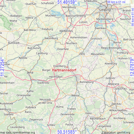
Hartmannsdorf GPS coordinates[2]
50° 57' 38.988" North, 11° 58' 32.376" East
| Map corner | latitude | longitude |
|---|---|---|
| Upper-left | 51.40159°, | 11.27254° |
| Center: | 50.96083°, | 11.97566° |
| Lower-right: | 50.51585°, | 12.67879° |
| Map W x H: | 98.5×98.5 km | = 61.2×61.2mi |
| max Lat: | 55.01917° ⇑42.6% North |
| Hartmannsdorf: | 50.96083° |
| min Lat: | ⇓57.4% South 47.40724° |
| min Long | Hartmannsdorf | max Long |
| 5.92978° | 11.97566° | 14.98853° |
| W 81.5%⇐ | ⇒18.5% E |
Elevation
Elevation of Hartmannsdorf is 184 m = 604 ft, and this is 65.1 m = 214 ft below average elevation for this country.
| Max E: |
1256 m = 4121 ft | 55.7% |
| Avg. | 249.1 m = 817 ft | |
| Hartmannsdorf | 184 m = 604 ft | |
Min E: |
-5 m = -16 ft | 44.3% |
See also: Germany elevation on elevation.city.
Geographical zone
Hartmannsdorf is located in North temperate zone (between Tropic of Cancer and the Arctic Circle). Distance of this North polar circle is 1734.9 km =1078 mi to North.| Distance of | km | miles | from Hartmannsdorf |
|---|---|---|---|
| North Pole | 4340.7 | 2697.2 | to North |
| Arctic Circle | 1734.9 | 1078 | to North |
| Tropic Cancer | 3060.4 | 1901.6 | to South |
| Equator | 5666.3 | 3520.9 | to South |


Nearby cities:
15 places around Hartmannsdorf: (largest is in red/bold)
• Bad Klosterlausnitz
9.1 km =5.7 mi,  237°
237°
• Bad Köstritz
4.2 km =2.6 mi,  144°
144°
• Caaschwitz
2.1 km =1.3 mi,  125°
125°
• Droyßig
9.7 km =6 mi,  21°
21°
• Eisenberg
5.2 km =3.2 mi,  279°
279°
• Gösen
7.8 km =4.8 mi,  303°
303°
• Hainspitz
9.6 km =6 mi,  270°
270°
• Hartmannsdorf
7 km =4.3 mi,  165°
165°
• Haynsburg
9 km =5.6 mi,  44°
44°
• Rauda
2.5 km =1.6 mi,  248°
248°
• Silbitz
2.1 km =1.3 mi, 125°
• Tautenhain
5.6 km =3.5 mi,  224°
224°
• Walpernhain
6.5 km =4 mi,  343°
343°
• Weißenborn
7.9 km =4.9 mi, 238°
• Wetterzeube
5.2 km =3.2 mi,  33°
33°
Sources, notices
• [Note1] Compared only with cities in Germany existing in our database
• [Src1] Map data: © OpenStreetMap contributors (CC-BY-SA)
• [Src2] Other city data from geonames.org with taken over terms of usage.
• [Src3] Geographical zone / Annual Mean Temperature by Robert A. Rohde @ Wikipedia
