Weißenborn geodata
Weißenborn (Thuringia) is a seat of a fourth-order administrative division; located in Germany in Europe/Berlin (GMT+2) time zone. With population of 1,311 people, there are 6275 cities with bigger population in this country. Compared to other cities in Germany, 56.6% of cities are located further ↓South; 80% of cities are located further ←West and 61.3% of cities have lower elevation than Weißenborn. Note1


Weißenborn GPS coordinates[2]
50° 55' 26.148" North, 11° 52' 46.092" East
| Map corner | latitude | longitude |
|---|---|---|
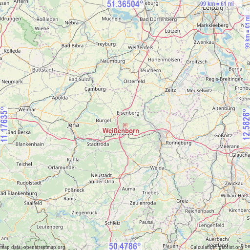
| Upper-left | 51.36504°, | 11.17635° |
| Center: | 50.92393°, | 11.87947° |
| Lower-right: | 50.4786°, | 12.5826° |
| Map W x H: | 98.6×98.6 km | = 61.3×61.3mi |
| max Lat: | 55.01917° ⇑43.4% North |
| Weißenborn: | 50.92393° |
| min Lat: | ⇓56.6% South 47.40724° |
| min Long | Weißenborn | max Long |
| 5.92978° | 11.87947° | 14.98853° |
| W 80%⇐ | ⇒20% E |
Elevation
Elevation of Weißenborn is 298 m = 978 ft, and this is 48.9 m = 160 ft above average elevation for this country.
| Max E: |
1256 m = 4121 ft | 38.7% |
| Weißenborn | 298 m 978 ft | |
| Avg. | 249.1 m = 817 ft | |
Min E: |
-5 m = -16 ft | 61.3% |
See also: Germany elevation on elevation.city.
Geographical zone
Weißenborn is located in North temperate zone (between Tropic of Cancer and the Arctic Circle). Distance of this North polar circle is 1739 km =1080.6 mi to North.| Distance of | km | miles | from Weißenborn |
|---|---|---|---|
| North Pole | 4344.9 | 2699.8 | to North |
| Arctic Circle | 1739 | 1080.6 | to North |
| Tropic Cancer | 3056.3 | 1899.1 | to South |
| Equator | 5662.2 | 3518.3 | to South |


Nearby cities:
15 places around Weißenborn: (largest is in red/bold)
• Bad Klosterlausnitz
1.2 km =0.7 mi,  228°
228°
• Bobeck
6.5 km =4 mi,  249°
249°
• Bollberg
7.2 km =4.5 mi, 230°
• Eisenberg
5.2 km =3.2 mi,  17°
17°
• Hainspitz
5 km =3.1 mi,  324°
324°
• Hermsdorf
3.4 km =2.1 mi,  209°
209°
• Kraftsdorf
6.4 km =4 mi,  146°
146°
• Petersberg
7.4 km =4.6 mi,  333°
333°
• Rauda
5.5 km =3.4 mi,  54°
54°
• Rauschwitz
7.3 km =4.5 mi,  310°
310°
• Reichenbach
6.2 km =3.9 mi,  180°
180°
• Schleifreisen
6.3 km =3.9 mi,  224°
224°
• Serba
5.3 km =3.3 mi,  303°
303°
• Tautenhain
2.8 km =1.7 mi,  88°
88°
• Waldeck
6.8 km =4.2 mi,  263°
263°
Sources, notices
• [Note1] Compared only with cities in Germany existing in our database
• [Src1] Map data: © OpenStreetMap contributors (CC-BY-SA)
• [Src2] Other city data from geonames.org with taken over terms of usage.
• [Src3] Geographical zone / Annual Mean Temperature by Robert A. Rohde @ Wikipedia
