Rauda geodata
Rauda (Thuringia) is a seat of a fourth-order administrative division; located in Germany in Europe/Berlin (GMT+2) time zone. With population of 357 people, there are 9842 cities with bigger population in this country. Compared to other cities in Germany, 57.3% of cities are located further ↓South; 81% of cities are located further ←West and 54% of cities have higher elevation than Rauda. Note1


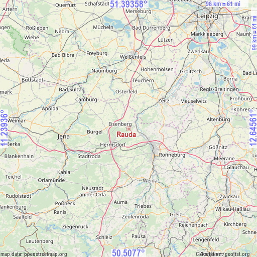
Rauda GPS coordinates[2]
50° 57' 9.9" North, 11° 56' 32.928" East
| Map corner | latitude | longitude |
|---|---|---|
| Upper-left | 51.39358°, | 11.23936° |
| Center: | 50.95275°, | 11.94248° |
| Lower-right: | 50.5077°, | 12.64561° |
| Map W x H: | 98.5×98.5 km | = 61.2×61.2mi |
| max Lat: | 55.01917° ⇑42.7% North |
| Rauda: | 50.95275° |
| min Lat: | ⇓57.3% South 47.40724° |
| min Long | Rauda | max Long |
| 5.92978° | 11.94248° | 14.98853° |
| W 81%⇐ | ⇒19% E |
Elevation
Elevation of Rauda is 197 m = 646 ft, and this is 52.1 m = 171 ft below average elevation for this country.
| Max E: |
1256 m = 4121 ft | 54% |
| Avg. | 249.1 m = 817 ft | |
| Rauda | 197 m = 646 ft | |
Min E: |
-5 m = -16 ft | 46% |
See also: Germany elevation on elevation.city.
Geographical zone
Rauda is located in North temperate zone (between Tropic of Cancer and the Arctic Circle). Distance of this North polar circle is 1735.8 km =1078.6 mi to North.| Distance of | km | miles | from Rauda |
|---|---|---|---|
| North Pole | 4341.6 | 2697.7 | to North |
| Arctic Circle | 1735.8 | 1078.6 | to North |
| Tropic Cancer | 3059.5 | 1901.1 | to South |
| Equator | 5665.4 | 3520.3 | to South |


Nearby cities:
15 places around Rauda: (largest is in red/bold)
• Bad Klosterlausnitz
6.7 km =4.2 mi,  232°
232°
• Bad Köstritz
5.4 km =3.4 mi,  117°
117°
• Caaschwitz
4 km =2.5 mi,  94°
94°
• Eisenberg
3.3 km =2.1 mi,  301°
301°
• Gösen
6.7 km =4.2 mi,  321°
321°
• Hainspitz
7.4 km =4.6 mi,  277°
277°
• Hartmannsdorf
2.5 km =1.6 mi,  68°
68°
• Hartmannsdorf
7.1 km =4.4 mi,  145°
145°
• Kraftsdorf
8.6 km =5.3 mi,  186°
186°
• Petersberg
8.4 km =5.2 mi,  293°
293°
• Silbitz
4 km =2.5 mi, 94°
• Tautenhain
3.5 km =2.2 mi,  207°
207°
• Walpernhain
7.1 km =4.4 mi,  4°
4°
• Weißenborn
5.5 km =3.4 mi, 234°
• Wetterzeube
7.4 km =4.6 mi,  44°
44°
Sources, notices
• [Note1] Compared only with cities in Germany existing in our database
• [Src1] Map data: © OpenStreetMap contributors (CC-BY-SA)
• [Src2] Other city data from geonames.org with taken over terms of usage.
• [Src3] Geographical zone / Annual Mean Temperature by Robert A. Rohde @ Wikipedia
