Halblech geodata
Halblech (Bavaria) is a seat of a fourth-order administrative division; located in Germany in Europe/Berlin (GMT+2) time zone. With population of 3,521 people, there are 3596 cities with bigger population in this country. Compared to other cities in Germany, 99.4% of cities are located further ↑North; 64.4% of cities are located further ←West and 99.3% of cities have lower elevation than Halblech. Note1
Administrative division(s):
- Level 1: Bavaria
- Level 2: Swabia
- Level 3: Landkreis Ostallgäu
- Level 4: Halblech


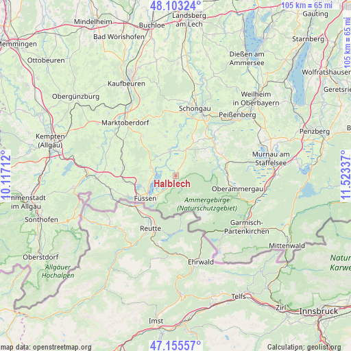
Halblech GPS coordinates[2]
47° 37' 53.58" North, 10° 49' 12.864" East
| Map corner | latitude | longitude |
|---|---|---|
| Upper-left | 48.10324°, | 10.11712° |
| Center: | 47.63155°, | 10.82024° |
| Lower-right: | 47.15557°, | 11.52337° |
| Map W x H: | 105.4×105.4 km | = 65.5×65.5mi |
| max Lat: | 55.01917° ⇑99.4% North |
| Halblech: | 47.63155° |
| min Lat: | ⇓0.6% South 47.40724° |
| min Long | Halblech | max Long |
| 5.92978° | 10.82024° | 14.98853° |
| W 64.4%⇐ | ⇒35.6% E |
Elevation
Elevation of Halblech is 810 m = 2657 ft, and this is 560.9 m = 1840 ft above average elevation for this country.
| Max E: |
1256 m = 4121 ft | 0.7% |
| Halblech | 810 m 2657 ft | |
| Avg. | 249.1 m = 817 ft | |
Min E: |
-5 m = -16 ft | 99.3% |
See also: Germany elevation on elevation.city.
Geographical zone
Halblech is located in North temperate zone (between Tropic of Cancer and the Arctic Circle). Distance of this North polar circle is 2105 km =1308 mi to North.| Distance of | km | miles | from Halblech |
|---|---|---|---|
| North Pole | 4710.9 | 2927.2 | to North |
| Arctic Circle | 2105 | 1308 | to North |
| Tropic Cancer | 2690.2 | 1671.6 | to South |
| Equator | 5296.1 | 3290.8 | to South |


Nearby cities:
15 places around Halblech: (largest is in red/bold)
• Bernbeuren
12.2 km =7.6 mi,  344°
344°
• Eisenberg
16.1 km =10 mi,  262°
262°
• Füssen
11.1 km =6.9 mi,  233°
233°
• Hohenschwangau
10.3 km =6.4 mi,  215°
215°
• Hopferau
14.1 km =8.8 mi, 263°
• Lechbruck
8 km =5 mi,  346°
346°
• Prem
6 km =3.7 mi, 345°
• Rottenbuch
15.8 km =9.8 mi,  44°
44°
• Roßhaupten
8 km =5 mi,  284°
284°
• Saulgrub
15.8 km =9.8 mi,  75°
75°
• Schwangau
8.8 km =5.5 mi, 226°
• Steingaden
8.4 km =5.2 mi,  24°
24°
• Stötten am Auerberg
15.5 km =9.6 mi,  320°
320°
• Unterammergau
15.6 km =9.7 mi,  96°
96°
• Wildsteig
11.7 km =7.3 mi,  48°
48°
Sources, notices
• [Note1] Compared only with cities in Germany existing in our database
• [Src1] Map data: © OpenStreetMap contributors (CC-BY-SA)
• [Src2] Other city data from geonames.org with taken over terms of usage.
• [Src3] Geographical zone / Annual Mean Temperature by Robert A. Rohde @ Wikipedia
