Hermsdorf geodata
Hermsdorf (Thuringia) is a seat of a fourth-order administrative division; located in Germany in Europe/Berlin (GMT+2) time zone. With population of 7,800 people, there are 1989 cities with bigger population in this country. Compared to other cities in Germany, 56% of cities are located further ↓South; 79.6% of cities are located further ←West and 66.4% of cities have lower elevation than Hermsdorf. Note1


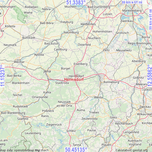
Hermsdorf GPS coordinates[2]
50° 53' 48.984" North, 11° 51' 19.764" East
| Map corner | latitude | longitude |
|---|---|---|
| Upper-left | 51.3383°, | 11.15237° |
| Center: | 50.89694°, | 11.85549° |
| Lower-right: | 50.45135°, | 12.55862° |
| Map W x H: | 98.6×98.6 km | = 61.3×61.3mi |
| max Lat: | 55.01917° ⇑44% North |
| Hermsdorf: | 50.89694° |
| min Lat: | ⇓56% South 47.40724° |
| min Long | Hermsdorf | max Long |
| 5.92978° | 11.85549° | 14.98853° |
| W 79.6%⇐ | ⇒20.4% E |
Elevation
Elevation of Hermsdorf is 331 m = 1086 ft, and this is 81.9 m = 269 ft above average elevation for this country.
| Max E: |
1256 m = 4121 ft | 33.6% |
| Hermsdorf | 331 m 1086 ft | |
| Avg. | 249.1 m = 817 ft | |
Min E: |
-5 m = -16 ft | 66.4% |
See also: Germany elevation on elevation.city.
Geographical zone
Hermsdorf is located in North temperate zone (between Tropic of Cancer and the Arctic Circle). Distance of this North polar circle is 1742 km =1082.4 mi to North.| Distance of | km | miles | from Hermsdorf |
|---|---|---|---|
| North Pole | 4347.9 | 2701.7 | to North |
| Arctic Circle | 1742 | 1082.4 | to North |
| Tropic Cancer | 3053.3 | 1897.2 | to South |
| Equator | 5659.2 | 3516.5 | to South |


Nearby cities:
15 places around Hermsdorf: (largest is in red/bold)
• Albersdorf
5.8 km =3.6 mi,  276°
276°
• Bad Klosterlausnitz
2.3 km =1.4 mi,  19°
19°
• Bobeck
4.4 km =2.7 mi, 279°
• Bollberg
4.2 km =2.6 mi,  248°
248°
• Eineborn
7.1 km =4.4 mi,  173°
173°
• Kraftsdorf
5.7 km =3.5 mi,  114°
114°
• Lindenkreuz
6.8 km =4.2 mi,  140°
140°
• Mörsdorf
5 km =3.1 mi,  233°
233°
• Reichenbach
3.5 km =2.2 mi,  153°
153°
• Sankt Gangloff
5.4 km =3.4 mi, 149°
• Schleifreisen
3.1 km =1.9 mi,  240°
240°
• Serba
6.5 km =4 mi,  335°
335°
• Tautenhain
5.4 km =3.4 mi,  55°
55°
• Waldeck
5.5 km =3.4 mi,  293°
293°
• Weißenborn
3.4 km =2.1 mi,  29°
29°
Sources, notices
• [Note1] Compared only with cities in Germany existing in our database
• [Src1] Map data: © OpenStreetMap contributors (CC-BY-SA)
• [Src2] Other city data from geonames.org with taken over terms of usage.
• [Src3] Geographical zone / Annual Mean Temperature by Robert A. Rohde @ Wikipedia
