Steeden geodata
Steeden (Hesse) is a populated place; located in Germany in Europe/Berlin (GMT+2) time zone. With population of 1,526 people, there are 5830 cities with bigger population in this country. Compared to other cities in Germany, 54.4% of cities are located further ↑North; 75% of cities are located further →East and 65.6% of cities have higher elevation than Steeden. Note1
Administrative division(s):
- Level 1: Hesse
- Level 2: Regierungsbezirk Gießen
- Level 3: Landkreis Limburg-Weilburg
- Level 4: Runkel


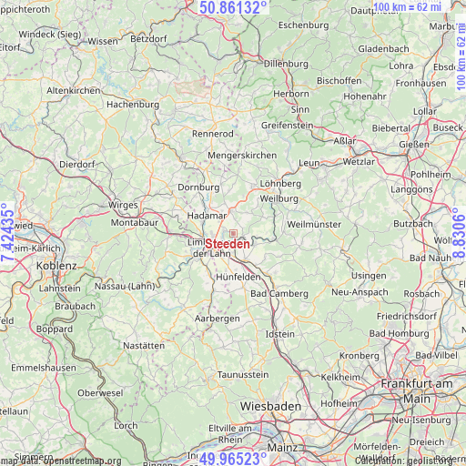
Steeden GPS coordinates[2]
50° 24' 55.404" North, 8° 7' 38.928" East
| Map corner | latitude | longitude |
|---|---|---|
| Upper-left | 50.86132°, | 7.42435° |
| Center: | 50.41539°, | 8.12748° |
| Lower-right: | 49.96523°, | 8.8306° |
| Map W x H: | 99.6×99.6 km | = 61.9×61.9mi |
| max Lat: | 55.01917° ⇑54.4% North |
| Steeden: | 50.41539° |
| min Lat: | ⇓45.6% South 47.40724° |
| min Long | Steeden | max Long |
| 5.92978° | 8.12748° | 14.98853° |
| W 25%⇐ | ⇒75% E |
Elevation
Elevation of Steeden is 117 m = 384 ft, and this is 132.1 m = 433 ft below average elevation for this country.
| Max E: |
1256 m = 4121 ft | 65.6% |
| Avg. | 249.1 m = 817 ft | |
| Steeden | 117 m = 384 ft | |
Min E: |
-5 m = -16 ft | 34.4% |
See also: Germany elevation on elevation.city.
Geographical zone
Steeden is located in North temperate zone (between Tropic of Cancer and the Arctic Circle). Distance of this North polar circle is 1795.5 km =1115.7 mi to North.| Distance of | km | miles | from Steeden |
|---|---|---|---|
| North Pole | 4401.4 | 2734.9 | to North |
| Arctic Circle | 1795.5 | 1115.7 | to North |
| Tropic Cancer | 2999.7 | 1863.9 | to South |
| Equator | 5605.7 | 3483.2 | to South |


Nearby cities:
15 places around Steeden: (largest is in red/bold)
• Aull
9.5 km =5.9 mi,  249°
249°
• Dehrn
2.1 km =1.3 mi,  285°
285°
• Diez
9.7 km =6 mi,  241°
241°
• Elz
6.7 km =4.2 mi,  271°
271°
• Flacht
9.5 km =5.9 mi,  215°
215°
• Gückingen
8.9 km =5.5 mi, 252°
• Hadamar
6.9 km =4.3 mi,  299°
299°
• Hambach
10.4 km =6.5 mi,  260°
260°
• Heistenbach
10.8 km =6.7 mi, 248°
• Holzheim
8.8 km =5.5 mi, 219°
• Limburg an der Lahn
6.5 km =4 mi, 237°
• Niederneisen
10.7 km =6.6 mi,  211°
211°
• Oberneisen
10.6 km =6.6 mi,  199°
199°
• Runkel
2.2 km =1.4 mi,  119°
119°
• Villmar
5.3 km =3.3 mi, 118°
Sources, notices
• [Note1] Compared only with cities in Germany existing in our database
• [Src1] Map data: © OpenStreetMap contributors (CC-BY-SA)
• [Src2] Other city data from geonames.org with taken over terms of usage.
• [Src3] Geographical zone / Annual Mean Temperature by Robert A. Rohde @ Wikipedia
