Dehrn geodata
Dehrn (Hesse) is a populated place; located in Germany in Europe/Berlin (GMT+2) time zone. With population of 2,307 people, there are 4659 cities with bigger population in this country. Compared to other cities in Germany, 54.2% of cities are located further ↑North; 75.5% of cities are located further →East and 63.2% of cities have higher elevation than Dehrn. Note1
Administrative division(s):
- Level 1: Hesse
- Level 2: Regierungsbezirk Gießen
- Level 3: Landkreis Limburg-Weilburg
- Level 4: Runkel


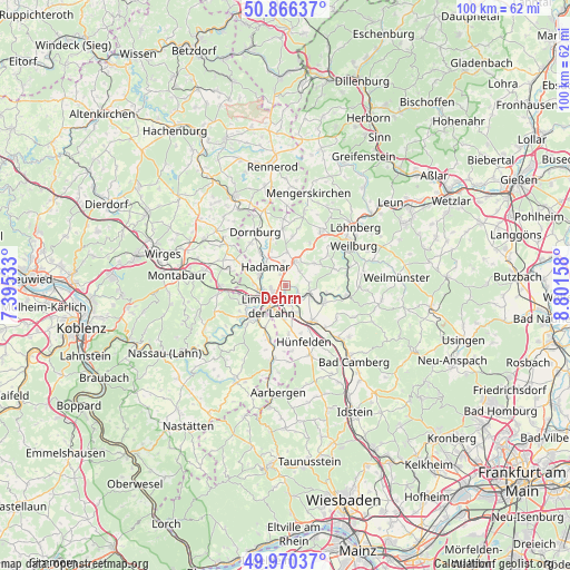
Dehrn GPS coordinates[2]
50° 25' 13.764" North, 8° 5' 54.456" East
| Map corner | latitude | longitude |
|---|---|---|
| Upper-left | 50.86637°, | 7.39533° |
| Center: | 50.42049°, | 8.09846° |
| Lower-right: | 49.97037°, | 8.80158° |
| Map W x H: | 99.6×99.6 km | = 61.9×61.9mi |
| max Lat: | 55.01917° ⇑54.2% North |
| Dehrn: | 50.42049° |
| min Lat: | ⇓45.8% South 47.40724° |
| min Long | Dehrn | max Long |
| 5.92978° | 8.09846° | 14.98853° |
| W 24.5%⇐ | ⇒75.5% E |
Elevation
Elevation of Dehrn is 131 m = 430 ft, and this is 118.1 m = 387 ft below average elevation for this country.
| Max E: |
1256 m = 4121 ft | 63.2% |
| Avg. | 249.1 m = 817 ft | |
| Dehrn | 131 m = 430 ft | |
Min E: |
-5 m = -16 ft | 36.8% |
See also: Germany elevation on elevation.city.
Geographical zone
Dehrn is located in North temperate zone (between Tropic of Cancer and the Arctic Circle). Distance of this North polar circle is 1794.9 km =1115.3 mi to North.| Distance of | km | miles | from Dehrn |
|---|---|---|---|
| North Pole | 4400.8 | 2734.5 | to North |
| Arctic Circle | 1794.9 | 1115.3 | to North |
| Tropic Cancer | 3000.3 | 1864.3 | to South |
| Equator | 5606.2 | 3483.5 | to South |


Nearby cities:
15 places around Dehrn: (largest is in red/bold)
• Aull
7.9 km =4.9 mi,  240°
240°
• Diez
8.3 km =5.2 mi,  231°
231°
• Elz
4.6 km =2.9 mi,  264°
264°
• Flacht
9 km =5.6 mi,  202°
202°
• Gückingen
7.3 km =4.5 mi, 243°
• Hadamar
4.9 km =3 mi,  305°
305°
• Hambach
8.5 km =5.3 mi,  254°
254°
• Heistenbach
9.2 km =5.7 mi, 240°
• Holzheim
8.2 km =5.1 mi,  205°
205°
• Hundsangen
8.8 km =5.5 mi,  291°
291°
• Limburg an der Lahn
5.3 km =3.3 mi,  219°
219°
• Niedererbach
8.8 km =5.5 mi,  274°
274°
• Runkel
4.3 km =2.7 mi,  112°
112°
• Steeden
2.1 km =1.3 mi, 105°
• Villmar
7.4 km =4.6 mi, 114°
Sources, notices
• [Note1] Compared only with cities in Germany existing in our database
• [Src1] Map data: © OpenStreetMap contributors (CC-BY-SA)
• [Src2] Other city data from geonames.org with taken over terms of usage.
• [Src3] Geographical zone / Annual Mean Temperature by Robert A. Rohde @ Wikipedia
