Ostrau geodata
Ostrau (Saxony-Anhalt) is a populated place; located in Germany in Europe/Berlin (GMT+2) time zone. With population of 994 people, there are 7207 cities with bigger population in this country. Compared to other cities in Germany, 63.4% of cities are located further ↓South; 82.6% of cities are located further ←West and 70.2% of cities have higher elevation than Ostrau. Note1


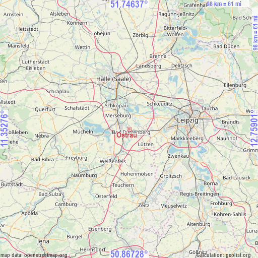
Ostrau GPS coordinates[2]
51° 18' 32.148" North, 12° 3' 21.168" East
| Map corner | latitude | longitude |
|---|---|---|
| Upper-left | 51.74637°, | 11.35276° |
| Center: | 51.30893°, | 12.05588° |
| Lower-right: | 50.86728°, | 12.75901° |
| Map W x H: | 97.7×97.7 km | = 60.7×60.7mi |
| max Lat: | 55.01917° ⇑36.6% North |
| Ostrau: | 51.30893° |
| min Lat: | ⇓63.4% South 47.40724° |
| min Long | Ostrau | max Long |
| 5.92978° | 12.05588° | 14.98853° |
| W 82.6%⇐ | ⇒17.4% E |
Elevation
Elevation of Ostrau is 90 m = 295 ft, and this is 159.1 m = 522 ft below average elevation for this country.
| Max E: |
1256 m = 4121 ft | 70.2% |
| Avg. | 249.1 m = 817 ft | |
| Ostrau | 90 m = 295 ft | |
Min E: |
-5 m = -16 ft | 29.8% |
See also: Germany elevation on elevation.city.
Geographical zone
Ostrau is located in North temperate zone (between Tropic of Cancer and the Arctic Circle). Distance of this North polar circle is 1696.2 km =1054 mi to North.| Distance of | km | miles | from Ostrau |
|---|---|---|---|
| North Pole | 4302 | 2673.1 | to North |
| Arctic Circle | 1696.2 | 1054 | to North |
| Tropic Cancer | 3099.1 | 1925.7 | to South |
| Equator | 5705 | 3544.9 | to South |


Nearby cities:
15 places around Ostrau: (largest is in red/bold)
• Bad Dürrenberg
1.7 km =1.1 mi,  155°
155°
• Beuna
7.4 km =4.6 mi,  276°
276°
• Großkorbetha
5.7 km =3.5 mi,  198°
198°
• Großlehna
8.1 km =5 mi,  91°
91°
• Kötzschau
5.2 km =3.2 mi, 85°
• Leuna
3 km =1.9 mi,  289°
289°
• Lützen
8.3 km =5.2 mi,  134°
134°
• Merseburg
6.9 km =4.3 mi,  317°
317°
• Schkortleben
7.8 km =4.8 mi, 200°
• Spergau
2.9 km =1.8 mi,  233°
233°
• Tollwitz
3.8 km =2.4 mi, 131°
• Wallendorf
5.8 km =3.6 mi,  13°
13°
• Wengelsdorf
3.2 km =2 mi, 197°
• Zscherben
6.7 km =4.2 mi,  296°
296°
• Zöschen
6.9 km =4.3 mi,  37°
37°
Sources, notices
• [Note1] Compared only with cities in Germany existing in our database
• [Src1] Map data: © OpenStreetMap contributors (CC-BY-SA)
• [Src2] Other city data from geonames.org with taken over terms of usage.
• [Src3] Geographical zone / Annual Mean Temperature by Robert A. Rohde @ Wikipedia
