Grünstadt geodata
Grünstadt (Rheinland-Pfalz) is a populated place; located in Germany in Europe/Berlin (GMT+2) time zone. With population of 13,424 people, there are 1193 cities with bigger population in this country. Compared to other cities in Germany, 74.6% of cities are located further ↑North; 74.6% of cities are located further →East and 56.7% of cities have higher elevation than Grünstadt. Note1
Administrative division(s):
- Level 1: Rheinland-Pfalz
- Level 3: Landkreis Bad Dürkheim
- Level 4: Grünstadt


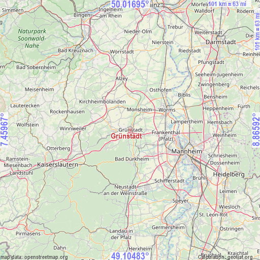
Grünstadt GPS coordinates[2]
49° 33' 46.872" North, 8° 9' 46.044" East
| Map corner | latitude | longitude |
|---|---|---|
| Upper-left | 50.01695°, | 7.45967° |
| Center: | 49.56302°, | 8.16279° |
| Lower-right: | 49.10483°, | 8.86592° |
| Map W x H: | 101.4×101.4 km | = 63×63mi |
| max Lat: | 55.01917° ⇑74.6% North |
| Grünstadt: | 49.56302° |
| min Lat: | ⇓25.4% South 47.40724° |
| min Long | Grünstadt | max Long |
| 5.92978° | 8.16279° | 14.98853° |
| W 25.4%⇐ | ⇒74.6% E |
Elevation
Elevation of Grünstadt is 177 m = 581 ft, and this is 72.1 m = 237 ft below average elevation for this country.
| Max E: |
1256 m = 4121 ft | 56.7% |
| Avg. | 249.1 m = 817 ft | |
| Grünstadt | 177 m = 581 ft | |
Min E: |
-5 m = -16 ft | 43.3% |
See also: Germany elevation on elevation.city.
Geographical zone
Grünstadt is located in North temperate zone (between Tropic of Cancer and the Arctic Circle). Distance of this North polar circle is 1890.3 km =1174.6 mi to North.| Distance of | km | miles | from Grünstadt |
|---|---|---|---|
| North Pole | 4496.2 | 2793.8 | to North |
| Arctic Circle | 1890.3 | 1174.6 | to North |
| Tropic Cancer | 2905 | 1805.1 | to South |
| Equator | 5510.9 | 3424.3 | to South |


Nearby cities:
15 places around Grünstadt: (largest is in red/bold)
• Bissersheim
4.2 km =2.6 mi,  135°
135°
• Bobenheim am Berg
4.4 km =2.7 mi,  191°
191°
• Bockenheim
5.1 km =3.2 mi,  18°
18°
• Dackenheim
5 km =3.1 mi,  159°
159°
• Ebertsheim
4 km =2.5 mi,  278°
278°
• Heidesheim
3.2 km =2 mi,  47°
47°
• Kirchheim an der Weinstraße
3.2 km =2 mi, 155°
• Kleinkarlbach
2.9 km =1.8 mi,  199°
199°
• Mertesheim
2.2 km =1.4 mi,  296°
296°
• Neuleiningen
2.9 km =1.8 mi,  215°
215°
• Obersülzen
3.6 km =2.2 mi,  80°
80°
• Obrigheim
4.4 km =2.7 mi,  43°
43°
• Quirnheim
3.5 km =2.2 mi,  312°
312°
• Rodenbach
4.2 km =2.6 mi,  287°
287°
• Tiefenthal
5 km =3.1 mi,  237°
237°
Sources, notices
• [Note1] Compared only with cities in Germany existing in our database
• [Src1] Map data: © OpenStreetMap contributors (CC-BY-SA)
• [Src2] Other city data from geonames.org with taken over terms of usage.
• [Src3] Geographical zone / Annual Mean Temperature by Robert A. Rohde @ Wikipedia
