Mertesheim geodata
Mertesheim (Rheinland-Pfalz) is a seat of a fourth-order administrative division; located in Germany in Europe/Berlin (GMT+2) time zone. With population of 402 people, there are 9686 cities with bigger population in this country. Compared to other cities in Germany, 74.4% of cities are located further ↑North; 74.9% of cities are located further →East and 59.1% of cities have higher elevation than Mertesheim. Note1
Administrative division(s):
- Level 1: Rheinland-Pfalz
- Level 3: Landkreis Bad Dürkheim
- Level 4: Mertesheim


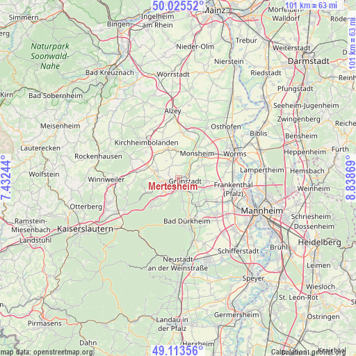
Mertesheim GPS coordinates[2]
49° 34' 18.012" North, 8° 8' 8.016" East
| Map corner | latitude | longitude |
|---|---|---|
| Upper-left | 50.02552°, | 7.43244° |
| Center: | 49.57167°, | 8.13556° |
| Lower-right: | 49.11356°, | 8.83869° |
| Map W x H: | 101.4×101.4 km | = 63×63mi |
| max Lat: | 55.01917° ⇑74.4% North |
| Mertesheim: | 49.57167° |
| min Lat: | ⇓25.6% South 47.40724° |
| min Long | Mertesheim | max Long |
| 5.92978° | 8.13556° | 14.98853° |
| W 25.1%⇐ | ⇒74.9% E |
Elevation
Elevation of Mertesheim is 160 m = 525 ft, and this is 89.1 m = 292 ft below average elevation for this country.
| Max E: |
1256 m = 4121 ft | 59.1% |
| Avg. | 249.1 m = 817 ft | |
| Mertesheim | 160 m = 525 ft | |
Min E: |
-5 m = -16 ft | 40.9% |
See also: Germany elevation on elevation.city.
Geographical zone
Mertesheim is located in North temperate zone (between Tropic of Cancer and the Arctic Circle). Distance of this North polar circle is 1889.3 km =1174 mi to North.| Distance of | km | miles | from Mertesheim |
|---|---|---|---|
| North Pole | 4495.2 | 2793.2 | to North |
| Arctic Circle | 1889.3 | 1174 | to North |
| Tropic Cancer | 2905.9 | 1805.6 | to South |
| Equator | 5511.9 | 3424.9 | to South |


Nearby cities:
15 places around Mertesheim: (largest is in red/bold)
• Biedesheim
4.2 km =2.6 mi,  331°
331°
• Bobenheim am Berg
5.4 km =3.4 mi,  168°
168°
• Bockenheim
5.3 km =3.3 mi,  42°
42°
• Ebertsheim
2 km =1.2 mi,  259°
259°
• Eisenberg
4.8 km =3 mi,  252°
252°
• Grünstadt
2.2 km =1.4 mi,  116°
116°
• Heidesheim
4.5 km =2.8 mi,  74°
74°
• Kindenheim
4.8 km =3 mi,  25°
25°
• Kirchheim an der Weinstraße
5 km =3.1 mi,  139°
139°
• Kleinkarlbach
3.8 km =2.4 mi,  164°
164°
• Lautersheim
3.2 km =2 mi,  302°
302°
• Neuleiningen
3.3 km =2.1 mi,  175°
175°
• Quirnheim
1.6 km =1 mi,  335°
335°
• Rodenbach
2.1 km =1.3 mi,  277°
277°
• Tiefenthal
4.3 km =2.7 mi,  211°
211°
Sources, notices
• [Note1] Compared only with cities in Germany existing in our database
• [Src1] Map data: © OpenStreetMap contributors (CC-BY-SA)
• [Src2] Other city data from geonames.org with taken over terms of usage.
• [Src3] Geographical zone / Annual Mean Temperature by Robert A. Rohde @ Wikipedia
