Dackenheim geodata
Dackenheim (Rheinland-Pfalz) is a seat of a fourth-order administrative division; located in Germany in Europe/Berlin (GMT+2) time zone. With population of 411 people, there are 9657 cities with bigger population in this country. Compared to other cities in Germany, 75.3% of cities are located further ↑North; 74.3% of cities are located further →East and 56.7% of cities have higher elevation than Dackenheim. Note1
Administrative division(s):
- Level 1: Rheinland-Pfalz
- Level 3: Landkreis Bad Dürkheim
- Level 4: Dackenheim


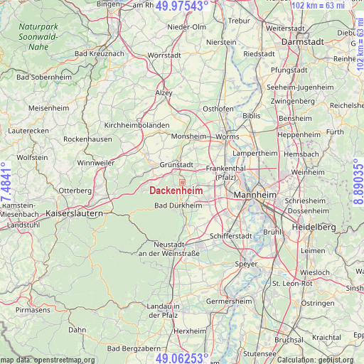
Dackenheim GPS coordinates[2]
49° 31' 15.996" North, 8° 11' 13.992" East
| Map corner | latitude | longitude |
|---|---|---|
| Upper-left | 49.97543°, | 7.4841° |
| Center: | 49.52111°, | 8.18722° |
| Lower-right: | 49.06253°, | 8.89035° |
| Map W x H: | 101.5×101.5 km | = 63.1×63.1mi |
| max Lat: | 55.01917° ⇑75.3% North |
| Dackenheim: | 49.52111° |
| min Lat: | ⇓24.7% South 47.40724° |
| min Long | Dackenheim | max Long |
| 5.92978° | 8.18722° | 14.98853° |
| W 25.7%⇐ | ⇒74.3% E |
Elevation
Elevation of Dackenheim is 177 m = 581 ft, and this is 72.1 m = 237 ft below average elevation for this country.
| Max E: |
1256 m = 4121 ft | 56.7% |
| Avg. | 249.1 m = 817 ft | |
| Dackenheim | 177 m = 581 ft | |
Min E: |
-5 m = -16 ft | 43.3% |
See also: Germany elevation on elevation.city.
Geographical zone
Dackenheim is located in North temperate zone (between Tropic of Cancer and the Arctic Circle). Distance of this North polar circle is 1894.9 km =1177.4 mi to North.| Distance of | km | miles | from Dackenheim |
|---|---|---|---|
| North Pole | 4500.8 | 2796.7 | to North |
| Arctic Circle | 1894.9 | 1177.4 | to North |
| Tropic Cancer | 2900.3 | 1802.2 | to South |
| Equator | 5506.2 | 3421.4 | to South |


Nearby cities:
15 places around Dackenheim: (largest is in red/bold)
• Bissersheim
2 km =1.2 mi,  36°
36°
• Bobenheim am Berg
2.6 km =1.6 mi,  277°
277°
• Erpolzheim
4.5 km =2.8 mi,  142°
142°
• Freinsheim
2.4 km =1.5 mi,  132°
132°
• Großkarlbach
3.3 km =2.1 mi,  54°
54°
• Grünstadt
5 km =3.1 mi,  339°
339°
• Herxheim am Berg
1.4 km =0.9 mi,  203°
203°
• Kallstadt
3.5 km =2.2 mi,  193°
193°
• Kirchheim an der Weinstraße
1.8 km =1.1 mi,  345°
345°
• Kleinkarlbach
3.3 km =2.1 mi,  305°
305°
• Laumersheim
5 km =3.1 mi, 43°
• Neuleiningen
4.2 km =2.6 mi,  303°
303°
• Obersülzen
5.5 km =3.4 mi,  18°
18°
• Weisenheim am Berg
2.6 km =1.6 mi,  249°
249°
• Weisenheim am Sand
4.4 km =2.7 mi,  94°
94°
Sources, notices
• [Note1] Compared only with cities in Germany existing in our database
• [Src1] Map data: © OpenStreetMap contributors (CC-BY-SA)
• [Src2] Other city data from geonames.org with taken over terms of usage.
• [Src3] Geographical zone / Annual Mean Temperature by Robert A. Rohde @ Wikipedia
