Kirchheim an der Weinstraße geodata
Kirchheim an der Weinstraße (Rheinland-Pfalz) is a seat of a fourth-order administrative division; located in Germany in Europe/Berlin (GMT+2) time zone. With population of 1,734 people, there are 5453 cities with bigger population in this country. Compared to other cities in Germany, 75% of cities are located further ↑North; 74.3% of cities are located further →East and 58.5% of cities have higher elevation than Kirchheim an der Weinstraße. Note1
Administrative division(s):
- Level 1: Rheinland-Pfalz
- Level 3: Landkreis Bad Dürkheim
- Level 4: Kirchheim an der Weinstraße
Current local time in Kirchheim an der Weinstraße:
02:39 PM, TuesdayDifference from your time zone: hours


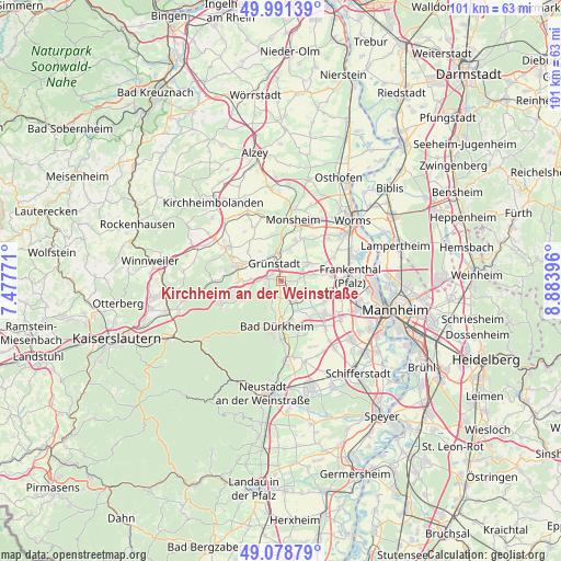
Kirchheim an der Weinstraße GPS coordinates[2]
49° 32' 13.992" North, 8° 10' 50.988" East
| Map corner | latitude | longitude |
|---|---|---|
| Upper-left | 49.99139°, | 7.47771° |
| Center: | 49.53722°, | 8.18083° |
| Lower-right: | 49.07879°, | 8.88396° |
| Map W x H: | 101.5×101.5 km | = 63.1×63.1mi |
| max Lat: | 55.01917° ⇑75% North |
| Kirchheim an der Weinstraße: | 49.53722° |
| min Lat: | ⇓25% South 47.40724° |
| min Long | Kirchheim an de | max Long |
| 5.92978° | 8.18083° | 14.98853° |
| W 25.7%⇐ | ⇒74.3% E |
Elevation
Elevation of Kirchheim an der Weinstraße is 164 m = 538 ft, and this is 85.1 m = 279 ft below average elevation for this country.
| Max E: |
1256 m = 4121 ft | 58.5% |
| Avg. | 249.1 m = 817 ft | |
| Kirchheim an der Weinstraße | 164 m = 538 ft | |
Min E: |
-5 m = -16 ft | 41.5% |
See also: Germany elevation on elevation.city.
Geographical zone
Kirchheim an der Weinstraße is located in North temperate zone (between Tropic of Cancer and the Arctic Circle). Distance of this North polar circle is 1893.2 km =1176.4 mi to North.| Distance of | km | miles | from Kirchheim an der Weinstraße |
|---|---|---|---|
| North Pole | 4499 | 2795.5 | to North |
| Arctic Circle | 1893.2 | 1176.4 | to North |
| Tropic Cancer | 2902.1 | 1803.3 | to South |
| Equator | 5508 | 3422.5 | to South |


Nearby cities:
15 places around Kirchheim an der Weinstraße: (largest is in red/bold)
• Bissersheim
1.7 km =1.1 mi,  95°
95°
• Bobenheim am Berg
2.6 km =1.6 mi,  235°
235°
• Dackenheim
1.8 km =1.1 mi,  165°
165°
• Freinsheim
4.1 km =2.5 mi,  146°
146°
• Großkarlbach
3.2 km =2 mi,  87°
87°
• Grünstadt
3.2 km =2 mi,  335°
335°
• Heidesheim
5.1 km =3.2 mi,  11°
11°
• Herxheim am Berg
3.1 km =1.9 mi,  182°
182°
• Kallstadt
5.2 km =3.2 mi, 183°
• Kleinkarlbach
2.3 km =1.4 mi,  273°
273°
• Laumersheim
4.4 km =2.7 mi,  64°
64°
• Mertesheim
5 km =3.1 mi,  319°
319°
• Neuleiningen
3.1 km =1.9 mi,  279°
279°
• Obersülzen
4.1 km =2.5 mi,  32°
32°
• Weisenheim am Berg
3.3 km =2.1 mi,  215°
215°
Sources, notices
• [Note1] Compared only with cities in Germany existing in our database
• [Src1] Map data: © OpenStreetMap contributors (CC-BY-SA)
• [Src2] Other city data from geonames.org with taken over terms of usage.
• [Src3] Geographical zone / Annual Mean Temperature by Robert A. Rohde @ Wikipedia
