Zabeltitz geodata
Zabeltitz (Saxony) is a populated place; located in Germany in Europe/Berlin (GMT+2) time zone. With population of 3,047 people, there are 3964 cities with bigger population in this country. Compared to other cities in Germany, 64.1% of cities are located further ↓South; 95.8% of cities are located further ←West and 66.5% of cities have higher elevation than Zabeltitz. Note1


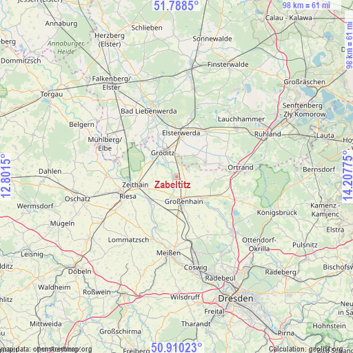
Zabeltitz GPS coordinates[2]
51° 21' 5.292" North, 13° 30' 16.632" East
| Map corner | latitude | longitude |
|---|---|---|
| Upper-left | 51.7885°, | 12.8015° |
| Center: | 51.35147°, | 13.50462° |
| Lower-right: | 50.91023°, | 14.20775° |
| Map W x H: | 97.7×97.7 km | = 60.7×60.7mi |
| max Lat: | 55.01917° ⇑35.9% North |
| Zabeltitz: | 51.35147° |
| min Lat: | ⇓64.1% South 47.40724° |
| min Long | Zabeltitz | max Long |
| 5.92978° | 13.50462° | 14.98853° |
| W 95.8%⇐ | ⇒4.2% E |
Elevation
Elevation of Zabeltitz is 111 m = 364 ft, and this is 138.1 m = 453 ft below average elevation for this country.
| Max E: |
1256 m = 4121 ft | 66.5% |
| Avg. | 249.1 m = 817 ft | |
| Zabeltitz | 111 m = 364 ft | |
Min E: |
-5 m = -16 ft | 33.5% |
See also: Germany elevation on elevation.city.
Geographical zone
Zabeltitz is located in North temperate zone (between Tropic of Cancer and the Arctic Circle). Distance of this North polar circle is 1691.4 km =1051 mi to North.| Distance of | km | miles | from Zabeltitz |
|---|---|---|---|
| North Pole | 4297.3 | 2670.2 | to North |
| Arctic Circle | 1691.4 | 1051 | to North |
| Tropic Cancer | 3103.8 | 1928.6 | to South |
| Equator | 5709.7 | 3547.8 | to South |


Nearby cities:
15 places around Zabeltitz: (largest is in red/bold)
• Elsterwerda
12.2 km =7.6 mi,  5°
5°
• Glaubitz
9.3 km =5.8 mi,  251°
251°
• Großenhain
7.2 km =4.5 mi,  163°
163°
• Großthiemig
11.8 km =7.3 mi,  72°
72°
• Gröden
6.9 km =4.3 mi,  38°
38°
• Hirschfeld
8.5 km =5.3 mi, 65°
• Lampertswalde
12.8 km =8 mi,  110°
110°
• Merzdorf
5.8 km =3.6 mi,  20°
20°
• Nauwalde
9.9 km =6.2 mi,  318°
318°
• Nünchritz
10.1 km =6.3 mi,  235°
235°
• Priestewitz
11.3 km =7 mi,  175°
175°
• Weißig
8 km =5 mi,  213°
213°
• Wildenhain
5.2 km =3.2 mi,  201°
201°
• Wülknitz
7.5 km =4.7 mi,  283°
283°
• Zeithain
11.7 km =7.3 mi,  260°
260°
Sources, notices
• [Note1] Compared only with cities in Germany existing in our database
• [Src1] Map data: © OpenStreetMap contributors (CC-BY-SA)
• [Src2] Other city data from geonames.org with taken over terms of usage.
• [Src3] Geographical zone / Annual Mean Temperature by Robert A. Rohde @ Wikipedia
