Wegeleben geodata
Wegeleben (Saxony-Anhalt) is a populated place; located in Germany in Europe/Berlin (GMT+2) time zone. With population of 3,132 people, there are 3886 cities with bigger population in this country. Compared to other cities in Germany, 70.9% of cities are located further ↓South; 69.5% of cities are located further ←West and 68.5% of cities have higher elevation than Wegeleben. Note1


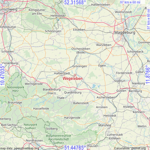
Wegeleben GPS coordinates[2]
51° 53' 1.536" North, 11° 10' 24.492" East
| Map corner | latitude | longitude |
|---|---|---|
| Upper-left | 52.31568°, | 10.47035° |
| Center: | 51.88376°, | 11.17347° |
| Lower-right: | 51.44765°, | 11.8766° |
| Map W x H: | 96.5×96.5 km | = 60×60mi |
| max Lat: | 55.01917° ⇑29.1% North |
| Wegeleben: | 51.88376° |
| min Lat: | ⇓70.9% South 47.40724° |
| min Long | Wegeleben | max Long |
| 5.92978° | 11.17347° | 14.98853° |
| W 69.5%⇐ | ⇒30.5% E |
Elevation
Elevation of Wegeleben is 100 m = 328 ft, and this is 149.1 m = 489 ft below average elevation for this country.
| Max E: |
1256 m = 4121 ft | 68.5% |
| Avg. | 249.1 m = 817 ft | |
| Wegeleben | 100 m = 328 ft | |
Min E: |
-5 m = -16 ft | 31.5% |
See also: Germany elevation on elevation.city.
Geographical zone
Wegeleben is located in North temperate zone (between Tropic of Cancer and the Arctic Circle). Distance of this North polar circle is 1632.2 km =1014.2 mi to North.| Distance of | km | miles | from Wegeleben |
|---|---|---|---|
| North Pole | 4238.1 | 2633.4 | to North |
| Arctic Circle | 1632.2 | 1014.2 | to North |
| Tropic Cancer | 3163 | 1965.4 | to South |
| Equator | 5768.9 | 3584.6 | to South |


Nearby cities:
15 places around Wegeleben: (largest is in red/bold)
• Ditfurt
5.9 km =3.7 mi,  162°
162°
• Gatersleben
10.4 km =6.5 mi,  131°
131°
• Groß Quenstedt
6.7 km =4.2 mi,  324°
324°
• Gröningen
6.6 km =4.1 mi,  26°
26°
• Hakeborn
13.7 km =8.5 mi,  73°
73°
• Halberstadt
8.2 km =5.1 mi,  279°
279°
• Harsleben
5.4 km =3.4 mi,  249°
249°
• Hausneindorf
8.3 km =5.2 mi, 125°
• Hedersleben
5.9 km =3.7 mi,  117°
117°
• Kroppenstedt
11.3 km =7 mi,  54°
54°
• Langenstein
13.1 km =8.1 mi,  256°
256°
• Quedlinburg
10.7 km =6.6 mi,  188°
188°
• Schwanebeck
10 km =6.2 mi,  340°
340°
• Wedderstedt
6.9 km =4.3 mi,  135°
135°
• Westerhausen
11.8 km =7.3 mi,  222°
222°
Sources, notices
• [Note1] Compared only with cities in Germany existing in our database
• [Src1] Map data: © OpenStreetMap contributors (CC-BY-SA)
• [Src2] Other city data from geonames.org with taken over terms of usage.
• [Src3] Geographical zone / Annual Mean Temperature by Robert A. Rohde @ Wikipedia
