Gransebieth geodata
Gransebieth (Mecklenburg-Vorpommern) is a populated place; located in Germany in Europe/Berlin (GMT+2) time zone. With population of 704 people, there are 8295 cities with bigger population in this country. Compared to other cities in Germany, 93.4% of cities are located further ↓South; 91.3% of cities are located further ←West and 94.3% of cities have higher elevation than Gransebieth. Note1
Administrative division(s):
- Level 1: Mecklenburg-Vorpommern
- Level 3: Vorpommern-Rügen
- Level 4: Gransebieth


Gransebieth GPS coordinates[2]
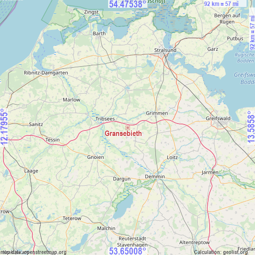
54° 3' 53.208" North, 12° 52' 57.612" East
| Map corner | latitude | longitude |
|---|---|---|
| Upper-left | 54.47538°, | 12.17955° |
| Center: | 54.06478°, | 12.88267° |
| Lower-right: | 53.65008°, | 13.5858° |
| Map W x H: | 91.8×91.8 km | = 57×57mi |
| max Lat: | 55.01917° ⇑6.6% North |
| Gransebieth: | 54.06478° |
| min Lat: | ⇓93.4% South 47.40724° |
| min Long | Gransebieth | max Long |
| 5.92978° | 12.88267° | 14.98853° |
| W 91.3%⇐ | ⇒8.7% E |
Elevation
Elevation of Gransebieth is 10 m = 33 ft, and this is 239.1 m = 784 ft below average elevation for this country.
| Max E: |
1256 m = 4121 ft | 94.3% |
| Avg. | 249.1 m = 817 ft | |
| Gransebieth | 10 m = 33 ft | |
Min E: |
-5 m = -16 ft | 5.7% |
See also: Germany elevation on elevation.city.
Geographical zone
Gransebieth is located in North temperate zone (between Tropic of Cancer and the Arctic Circle). Distance of this North polar circle is 1389.7 km =863.5 mi to North.| Distance of | km | miles | from Gransebieth |
|---|---|---|---|
| North Pole | 3995.6 | 2482.7 | to North |
| Arctic Circle | 1389.7 | 863.5 | to North |
| Tropic Cancer | 3405.5 | 2116.1 | to South |
| Equator | 6011.4 | 3735.3 | to South |


Nearby cities:
15 places around Gransebieth: (largest is in red/bold)
• Bad Sülze
15.4 km =9.6 mi,  289°
289°
• Behren-Lübchin
14.8 km =9.2 mi,  254°
254°
• Deyelsdorf
4.6 km =2.9 mi,  240°
240°
• Düvier
13.3 km =8.3 mi,  114°
114°
• Eixen
14.9 km =9.3 mi,  316°
316°
• Franzburg
13.4 km =8.3 mi,  359°
359°
• Glewitz
5.6 km =3.5 mi,  151°
151°
• Grammendorf
3.3 km =2.1 mi,  189°
189°
• Grimmen
11.6 km =7.2 mi,  62°
62°
• Nossendorf
12.5 km =7.8 mi,  156°
156°
• Richtenberg
15.2 km =9.4 mi,  2°
2°
• Splietsdorf
7.3 km =4.5 mi,  25°
25°
• Stubbendorf
13.6 km =8.5 mi,  199°
199°
• Tribsees
8.9 km =5.5 mi, 292°
• Wendisch Baggendorf
4.1 km =2.5 mi,  75°
75°
Sources, notices
• [Note1] Compared only with cities in Germany existing in our database
• [Src1] Map data: © OpenStreetMap contributors (CC-BY-SA)
• [Src2] Other city data from geonames.org with taken over terms of usage.
• [Src3] Geographical zone / Annual Mean Temperature by Robert A. Rohde @ Wikipedia
