Wendisch Baggendorf geodata
Wendisch Baggendorf (Mecklenburg-Vorpommern) is a populated place; located in Germany in Europe/Berlin (GMT+2) time zone. With population of 595 people, there are 8857 cities with bigger population in this country. Compared to other cities in Germany, 93.6% of cities are located further ↓South; 91.8% of cities are located further ←West and 90.9% of cities have higher elevation than Wendisch Baggendorf. Note1
Administrative division(s):
- Level 1: Mecklenburg-Vorpommern
- Level 3: Vorpommern-Rügen
- Level 4: Wendisch Baggendorf


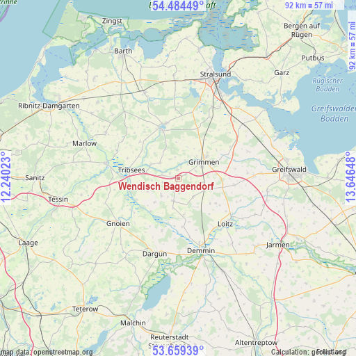
Wendisch Baggendorf GPS coordinates[2]
54° 4' 26.364" North, 12° 56' 36.06" East
| Map corner | latitude | longitude |
|---|---|---|
| Upper-left | 54.48449°, | 12.24023° |
| Center: | 54.07399°, | 12.94335° |
| Lower-right: | 53.65939°, | 13.64648° |
| Map W x H: | 91.7×91.7 km | = 57×57mi |
| max Lat: | 55.01917° ⇑6.4% North |
| Wendisch Baggendorf: | 54.07399° |
| min Lat: | ⇓93.6% South 47.40724° |
| min Long | Wendisch Baggen | max Long |
| 5.92978° | 12.94335° | 14.98853° |
| W 91.8%⇐ | ⇒8.2% E |
Elevation
Elevation of Wendisch Baggendorf is 19 m = 62 ft, and this is 230.1 m = 755 ft below average elevation for this country.
| Max E: |
1256 m = 4121 ft | 90.9% |
| Avg. | 249.1 m = 817 ft | |
| Wendisch Baggendorf | 19 m = 62 ft | |
Min E: |
-5 m = -16 ft | 9.1% |
See also: Germany elevation on elevation.city.
Geographical zone
Wendisch Baggendorf is located in North temperate zone (between Tropic of Cancer and the Arctic Circle). Distance of this North polar circle is 1388.7 km =862.9 mi to North.| Distance of | km | miles | from Wendisch Baggendorf |
|---|---|---|---|
| North Pole | 3994.6 | 2482.1 | to North |
| Arctic Circle | 1388.7 | 862.9 | to North |
| Tropic Cancer | 3406.5 | 2116.7 | to South |
| Equator | 6012.5 | 3736 | to South |


Nearby cities:
15 places around Wendisch Baggendorf: (largest is in red/bold)
• Deyelsdorf
8.6 km =5.3 mi,  247°
247°
• Düvier
10.4 km =6.5 mi,  128°
128°
• Franzburg
13 km =8.1 mi,  342°
342°
• Glewitz
6.1 km =3.8 mi,  191°
191°
• Grammendorf
6.2 km =3.9 mi,  226°
226°
• Gransebieth
4.1 km =2.5 mi,  255°
255°
• Grimmen
7.6 km =4.7 mi,  56°
56°
• Nossendorf
12.5 km =7.8 mi,  175°
175°
• Richtenberg
14.5 km =9 mi,  347°
347°
• Sassen
16.9 km =10.5 mi,  109°
109°
• Splietsdorf
5.6 km =3.5 mi, 351°
• Stoltenhagen
12.8 km =8 mi,  43°
43°
• Stubbendorf
16.2 km =10.1 mi,  211°
211°
• Tribsees
12.4 km =7.7 mi,  281°
281°
• Wittenhagen
14.8 km =9.2 mi,  34°
34°
Sources, notices
• [Note1] Compared only with cities in Germany existing in our database
• [Src1] Map data: © OpenStreetMap contributors (CC-BY-SA)
• [Src2] Other city data from geonames.org with taken over terms of usage.
• [Src3] Geographical zone / Annual Mean Temperature by Robert A. Rohde @ Wikipedia
