Grafenwöhr geodata
Grafenwöhr (Bavaria) is a populated place; located in Germany in Europe/Berlin (GMT+2) time zone. With population of 6,790 people, there are 2237 cities with bigger population in this country. Compared to other cities in Germany, 70.9% of cities are located further ↑North; 80.4% of cities are located further ←West and 77.4% of cities have lower elevation than Grafenwöhr. Note1
Administrative division(s):
- Level 1: Bavaria
- Level 2: Upper Palatinate
- Level 3: Landkreis Neustadt an der Waldnaab
- Level 4: Grafenwöhr


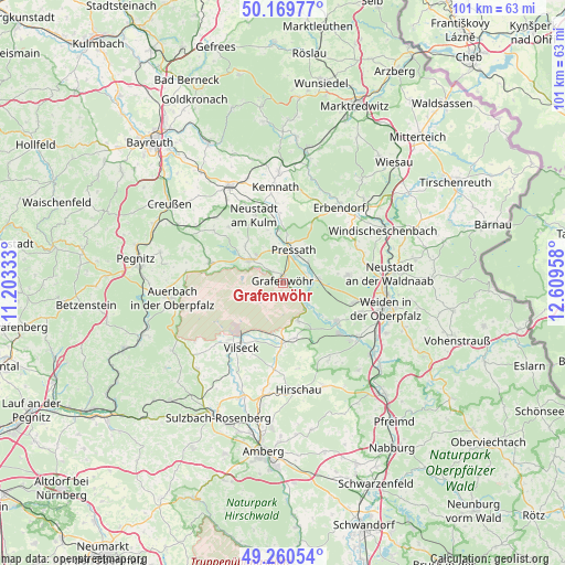
Grafenwöhr GPS coordinates[2]
49° 43' 2.208" North, 11° 54' 23.22" East
| Map corner | latitude | longitude |
|---|---|---|
| Upper-left | 50.16977°, | 11.20333° |
| Center: | 49.71728°, | 11.90645° |
| Lower-right: | 49.26054°, | 12.60958° |
| Map W x H: | 101.1×101.1 km | = 62.8×62.8mi |
| max Lat: | 55.01917° ⇑70.9% North |
| Grafenwöhr: | 49.71728° |
| min Lat: | ⇓29.1% South 47.40724° |
| min Long | Grafenwöhr | max Long |
| 5.92978° | 11.90645° | 14.98853° |
| W 80.4%⇐ | ⇒19.6% E |
Elevation
Elevation of Grafenwöhr is 415 m = 1362 ft, and this is 165.9 m = 544 ft above average elevation for this country.
| Max E: |
1256 m = 4121 ft | 22.6% |
| Grafenwöhr | 415 m 1362 ft | |
| Avg. | 249.1 m = 817 ft | |
Min E: |
-5 m = -16 ft | 77.4% |
See also: Germany elevation on elevation.city.
Geographical zone
Grafenwöhr is located in North temperate zone (between Tropic of Cancer and the Arctic Circle). Distance of this North polar circle is 1873.1 km =1163.9 mi to North.| Distance of | km | miles | from Grafenwöhr |
|---|---|---|---|
| North Pole | 4479 | 2783.1 | to North |
| Arctic Circle | 1873.1 | 1163.9 | to North |
| Tropic Cancer | 2922.1 | 1815.7 | to South |
| Equator | 5528 | 3434.9 | to South |


Nearby cities:
15 places around Grafenwöhr: (largest is in red/bold)
• Etzenricht
16.8 km =10.4 mi,  123°
123°
• Freihung
10.7 km =6.6 mi,  179°
179°
• Kastl
12.9 km =8 mi,  357°
357°
• Kirchendemenreuth
15.7 km =9.8 mi,  62°
62°
• Kirchenthumbach
13.5 km =8.4 mi,  285°
285°
• Kohlberg
16.2 km =10.1 mi,  149°
149°
• Mantel
11.9 km =7.4 mi,  126°
126°
• Parkstein
11.7 km =7.3 mi,  83°
83°
• Pressath
6.2 km =3.9 mi,  22°
22°
• Schlammersdorf
15.5 km =9.6 mi,  306°
306°
• Schwarzenbach
6.6 km =4.1 mi, 82°
• Speinshart
10.2 km =6.3 mi,  322°
322°
• Trabitz
9.2 km =5.7 mi, 357°
• Vilseck
13.6 km =8.5 mi,  213°
213°
• Weiherhammer
14.8 km =9.2 mi, 128°
Sources, notices
• [Note1] Compared only with cities in Germany existing in our database
• [Src1] Map data: © OpenStreetMap contributors (CC-BY-SA)
• [Src2] Other city data from geonames.org with taken over terms of usage.
• [Src3] Geographical zone / Annual Mean Temperature by Robert A. Rohde @ Wikipedia
