Parkstein geodata
Parkstein (Bavaria) is a populated place; located in Germany in Europe/Berlin (GMT+2) time zone. With population of 2,289 people, there are 4688 cities with bigger population in this country. Compared to other cities in Germany, 70.6% of cities are located further ↑North; 82.8% of cities are located further ←West and 89.8% of cities have lower elevation than Parkstein. Note1
Administrative division(s):
- Level 1: Bavaria
- Level 2: Upper Palatinate
- Level 3: Landkreis Neustadt an der Waldnaab
- Level 4: Parkstein, Markt


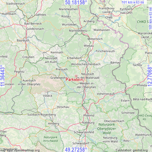
Parkstein GPS coordinates[2]
49° 43' 45.156" North, 12° 4' 3.18" East
| Map corner | latitude | longitude |
|---|---|---|
| Upper-left | 50.18158°, | 11.36443° |
| Center: | 49.72921°, | 12.06755° |
| Lower-right: | 49.27258°, | 12.77068° |
| Map W x H: | 101.1×101.1 km | = 62.8×62.8mi |
| max Lat: | 55.01917° ⇑70.6% North |
| Parkstein: | 49.72921° |
| min Lat: | ⇓29.4% South 47.40724° |
| min Long | Parkstein | max Long |
| 5.92978° | 12.06755° | 14.98853° |
| W 82.8%⇐ | ⇒17.2% E |
Elevation
Elevation of Parkstein is 511 m = 1677 ft, and this is 261.9 m = 859 ft above average elevation for this country.
| Max E: |
1256 m = 4121 ft | 10.2% |
| Parkstein | 511 m 1677 ft | |
| Avg. | 249.1 m = 817 ft | |
Min E: |
-5 m = -16 ft | 89.8% |
See also: Germany elevation on elevation.city.
Geographical zone
Parkstein is located in North temperate zone (between Tropic of Cancer and the Arctic Circle). Distance of this North polar circle is 1871.8 km =1163.1 mi to North.| Distance of | km | miles | from Parkstein |
|---|---|---|---|
| North Pole | 4477.7 | 2782.3 | to North |
| Arctic Circle | 1871.8 | 1163.1 | to North |
| Tropic Cancer | 2923.5 | 1816.6 | to South |
| Equator | 5529.4 | 3435.8 | to South |


Nearby cities:
15 places around Parkstein: (largest is in red/bold)
• Berg
10.8 km =6.7 mi,  29°
29°
• Etzenricht
10.9 km =6.8 mi,  167°
167°
• Grafenwöhr
11.7 km =7.3 mi,  263°
263°
• Kirchendemenreuth
6.5 km =4 mi,  21°
21°
• Krummennaab
11.8 km =7.3 mi,  11°
11°
• Mantel
8.6 km =5.3 mi,  193°
193°
• Neustadt an der Waldnaab
7.9 km =4.9 mi,  87°
87°
• Pressath
10.2 km =6.3 mi,  295°
295°
• Püchersreuth
12.1 km =7.5 mi,  79°
79°
• Schirmitz
11.3 km =7 mi,  141°
141°
• Schwarzenbach
5.1 km =3.2 mi, 264°
• Störnstein
9.9 km =6.2 mi, 88°
• Weiden
8.6 km =5.3 mi,  132°
132°
• Weiherhammer
10.7 km =6.6 mi,  180°
180°
• Windischeschenbach
10.3 km =6.4 mi,  38°
38°
Sources, notices
• [Note1] Compared only with cities in Germany existing in our database
• [Src1] Map data: © OpenStreetMap contributors (CC-BY-SA)
• [Src2] Other city data from geonames.org with taken over terms of usage.
• [Src3] Geographical zone / Annual Mean Temperature by Robert A. Rohde @ Wikipedia
