Kirchenthumbach geodata
Kirchenthumbach (Bavaria) is a populated place; located in Germany in Europe/Berlin (GMT+2) time zone. With population of 3,448 people, there are 3657 cities with bigger population in this country. Compared to other cities in Germany, 70.2% of cities are located further ↑North; 77.6% of cities are located further ←West and 84.4% of cities have lower elevation than Kirchenthumbach. Note1
Administrative division(s):
- Level 1: Bavaria
- Level 2: Upper Palatinate
- Level 3: Landkreis Neustadt an der Waldnaab
- Level 4: Kirchenthumbach, Markt


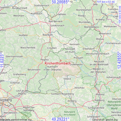
Kirchenthumbach GPS coordinates[2]
49° 44' 55.176" North, 11° 43' 31.512" East
| Map corner | latitude | longitude |
|---|---|---|
| Upper-left | 50.20085°, | 11.0223° |
| Center: | 49.74866°, | 11.72542° |
| Lower-right: | 49.29221°, | 12.42855° |
| Map W x H: | 101×101 km | = 62.8×62.8mi |
| max Lat: | 55.01917° ⇑70.2% North |
| Kirchenthumbach: | 49.74866° |
| min Lat: | ⇓29.8% South 47.40724° |
| min Long | Kirchenthumbach | max Long |
| 5.92978° | 11.72542° | 14.98853° |
| W 77.6%⇐ | ⇒22.4% E |
Elevation
Elevation of Kirchenthumbach is 464 m = 1522 ft, and this is 214.9 m = 705 ft above average elevation for this country.
| Max E: |
1256 m = 4121 ft | 15.6% |
| Kirchenthumbach | 464 m 1522 ft | |
| Avg. | 249.1 m = 817 ft | |
Min E: |
-5 m = -16 ft | 84.4% |
See also: Germany elevation on elevation.city.
Geographical zone
Kirchenthumbach is located in North temperate zone (between Tropic of Cancer and the Arctic Circle). Distance of this North polar circle is 1869.6 km =1161.7 mi to North.| Distance of | km | miles | from Kirchenthumbach |
|---|---|---|---|
| North Pole | 4475.5 | 2780.9 | to North |
| Arctic Circle | 1869.6 | 1161.7 | to North |
| Tropic Cancer | 2925.6 | 1817.9 | to South |
| Equator | 5531.5 | 3437.1 | to South |


Nearby cities:
15 places around Kirchenthumbach: (largest is in red/bold)
• Auerbach
9.1 km =5.7 mi,  226°
226°
• Creußen
12.8 km =8 mi,  326°
326°
• Grafenwöhr
13.5 km =8.4 mi,  105°
105°
• Kastl
15.7 km =9.8 mi,  53°
53°
• Pegnitz
13.2 km =8.2 mi,  271°
271°
• Prebitz
9.9 km =6.2 mi,  342°
342°
• Pressath
15.6 km =9.7 mi,  81°
81°
• Schlammersdorf
5.7 km =3.5 mi,  5°
5°
• Schnabelwaid
12.4 km =7.7 mi,  304°
304°
• Seybothenreuth
16.2 km =10.1 mi,  354°
354°
• Speichersdorf
14.2 km =8.8 mi,  16°
16°
• Speinshart
8.2 km =5.1 mi,  55°
55°
• Trabitz
13.8 km =8.6 mi,  65°
65°
• Vilseck
15.9 km =9.9 mi,  159°
159°
• Vorbach
8.1 km =5 mi, 5°
Sources, notices
• [Note1] Compared only with cities in Germany existing in our database
• [Src1] Map data: © OpenStreetMap contributors (CC-BY-SA)
• [Src2] Other city data from geonames.org with taken over terms of usage.
• [Src3] Geographical zone / Annual Mean Temperature by Robert A. Rohde @ Wikipedia
