Speinshart geodata
Speinshart (Bavaria) is a seat of a fourth-order administrative division; located in Germany in Europe/Berlin (GMT+2) time zone. With population of 1,181 people, there are 6616 cities with bigger population in this country. Compared to other cities in Germany, 69.2% of cities are located further ↑North; 79.1% of cities are located further ←West and 79.5% of cities have lower elevation than Speinshart. Note1
Administrative division(s):
- Level 1: Bavaria
- Level 2: Upper Palatinate
- Level 3: Landkreis Neustadt an der Waldnaab
- Level 4: Speinshart


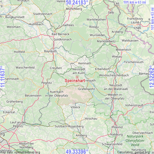
Speinshart GPS coordinates[2]
49° 47' 24.072" North, 11° 49' 10.164" East
| Map corner | latitude | longitude |
|---|---|---|
| Upper-left | 50.24183°, | 11.11637° |
| Center: | 49.79002°, | 11.81949° |
| Lower-right: | 49.33396°, | 12.52262° |
| Map W x H: | 100.9×100.9 km | = 62.7×62.7mi |
| max Lat: | 55.01917° ⇑69.2% North |
| Speinshart: | 49.79002° |
| min Lat: | ⇓30.8% South 47.40724° |
| min Long | Speinshart | max Long |
| 5.92978° | 11.81949° | 14.98853° |
| W 79.1%⇐ | ⇒20.9% E |
Elevation
Elevation of Speinshart is 430 m = 1411 ft, and this is 180.9 m = 594 ft above average elevation for this country.
| Max E: |
1256 m = 4121 ft | 20.5% |
| Speinshart | 430 m 1411 ft | |
| Avg. | 249.1 m = 817 ft | |
Min E: |
-5 m = -16 ft | 79.5% |
See also: Germany elevation on elevation.city.
Geographical zone
Speinshart is located in North temperate zone (between Tropic of Cancer and the Arctic Circle). Distance of this North polar circle is 1865 km =1158.9 mi to North.| Distance of | km | miles | from Speinshart |
|---|---|---|---|
| North Pole | 4470.9 | 2778.1 | to North |
| Arctic Circle | 1865 | 1158.9 | to North |
| Tropic Cancer | 2930.2 | 1820.7 | to South |
| Equator | 5536.1 | 3440 | to South |


Nearby cities:
15 places around Speinshart: (largest is in red/bold)
• Grafenwöhr
10.2 km =6.3 mi,  142°
142°
• Immenreuth
12.7 km =7.9 mi,  15°
15°
• Kastl
7.5 km =4.7 mi,  50°
50°
• Kemnath
10.3 km =6.4 mi,  29°
29°
• Kirchenthumbach
8.2 km =5.1 mi,  235°
235°
• Kulmain
13.5 km =8.4 mi, 25°
• Plößberg
14.9 km =9.3 mi,  13°
13°
• Prebitz
10.9 km =6.8 mi,  296°
296°
• Pressath
9 km =5.6 mi,  105°
105°
• Schlammersdorf
6.3 km =3.9 mi,  280°
280°
• Schwarzenbach
14.7 km =9.1 mi,  119°
119°
• Seybothenreuth
14.1 km =8.8 mi,  324°
324°
• Speichersdorf
9.4 km =5.8 mi,  343°
343°
• Trabitz
5.9 km =3.7 mi,  79°
79°
• Vorbach
6.9 km =4.3 mi, 300°
Sources, notices
• [Note1] Compared only with cities in Germany existing in our database
• [Src1] Map data: © OpenStreetMap contributors (CC-BY-SA)
• [Src2] Other city data from geonames.org with taken over terms of usage.
• [Src3] Geographical zone / Annual Mean Temperature by Robert A. Rohde @ Wikipedia
