Schnaittach geodata
Schnaittach (Bavaria) is a populated place; located in Germany in Europe/Berlin (GMT+2) time zone. With population of 8,238 people, there are 1916 cities with bigger population in this country. Compared to other cities in Germany, 74.6% of cities are located further ↑North; 71.9% of cities are located further ←West and 68.9% of cities have lower elevation than Schnaittach. Note1
Administrative division(s):
- Level 1: Bavaria
- Level 2: Regierungsbezirk Mittelfranken
- Level 3: Nürnberger Land
- Level 4: Schnaittach, Markt


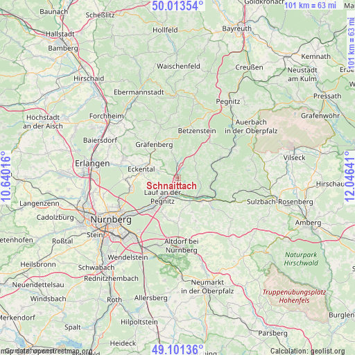
Schnaittach GPS coordinates[2]
49° 33' 34.488" North, 11° 20' 35.808" East
| Map corner | latitude | longitude |
|---|---|---|
| Upper-left | 50.01354°, | 10.64016° |
| Center: | 49.55958°, | 11.34328° |
| Lower-right: | 49.10136°, | 12.04641° |
| Map W x H: | 101.4×101.4 km | = 63×63mi |
| max Lat: | 55.01917° ⇑74.6% North |
| Schnaittach: | 49.55958° |
| min Lat: | ⇓25.4% South 47.40724° |
| min Long | Schnaittach | max Long |
| 5.92978° | 11.34328° | 14.98853° |
| W 71.9%⇐ | ⇒28.1% E |
Elevation
Elevation of Schnaittach is 349 m = 1145 ft, and this is 99.9 m = 328 ft above average elevation for this country.
| Max E: |
1256 m = 4121 ft | 31.1% |
| Schnaittach | 349 m 1145 ft | |
| Avg. | 249.1 m = 817 ft | |
Min E: |
-5 m = -16 ft | 68.9% |
See also: Germany elevation on elevation.city.
Geographical zone
Schnaittach is located in North temperate zone (between Tropic of Cancer and the Arctic Circle). Distance of this North polar circle is 1890.7 km =1174.8 mi to North.| Distance of | km | miles | from Schnaittach |
|---|---|---|---|
| North Pole | 4496.6 | 2794.1 | to North |
| Arctic Circle | 1890.7 | 1174.8 | to North |
| Tropic Cancer | 2904.6 | 1804.8 | to South |
| Equator | 5510.5 | 3424.1 | to South |


Nearby cities:
15 places around Schnaittach: (largest is in red/bold)
• Engelthal
10.6 km =6.6 mi,  157°
157°
• Henfenfeld
7.6 km =4.7 mi,  153°
153°
• Hersbruck
8.4 km =5.2 mi,  130°
130°
• Hiltpoltstein
11.3 km =7 mi,  352°
352°
• Igensdorf
10.7 km =6.6 mi,  311°
311°
• Kirchensittenbach
5.7 km =3.5 mi,  93°
93°
• Lauf an der Pegnitz
6.7 km =4.2 mi,  220°
220°
• Neunkirchen am Sand
4.2 km =2.6 mi,  203°
203°
• Ottensoos
5.6 km =3.5 mi,  181°
181°
• Reichenschwand
5.5 km =3.4 mi, 157°
• Röthenbach an der Pegnitz
11.3 km =7 mi, 220°
• Rückersdorf
9.8 km =6.1 mi,  225°
225°
• Simmelsdorf
4.3 km =2.7 mi,  355°
355°
• Vorra
10.9 km =6.8 mi, 91°
• Weißenohe
10.2 km =6.3 mi,  320°
320°
Sources, notices
• [Note1] Compared only with cities in Germany existing in our database
• [Src1] Map data: © OpenStreetMap contributors (CC-BY-SA)
• [Src2] Other city data from geonames.org with taken over terms of usage.
• [Src3] Geographical zone / Annual Mean Temperature by Robert A. Rohde @ Wikipedia
