Drogen geodata
Drogen (Thuringia) is a seat of a fourth-order administrative division; located in Germany in Europe/Berlin (GMT+2) time zone. With population of 161 people, there are 10640 cities with bigger population in this country. Compared to other cities in Germany, 56.4% of cities are located further ↓South; 85.9% of cities are located further ←West and 55.8% of cities have lower elevation than Drogen. Note1


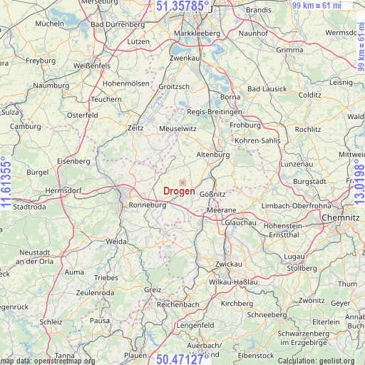
Drogen GPS coordinates[2]
50° 55' 0.012" North, 12° 19' 0.012" East
| Map corner | latitude | longitude |
|---|---|---|
| Upper-left | 51.35785°, | 11.61355° |
| Center: | 50.91667°, | 12.31667° |
| Lower-right: | 50.47127°, | 13.0198° |
| Map W x H: | 98.6×98.6 km | = 61.3×61.3mi |
| max Lat: | 55.01917° ⇑43.6% North |
| Drogen: | 50.91667° |
| min Lat: | ⇓56.4% South 47.40724° |
| min Long | Drogen | max Long |
| 5.92978° | 12.31667° | 14.98853° |
| W 85.9%⇐ | ⇒14.1% E |
Elevation
Elevation of Drogen is 264 m = 866 ft, and this is 14.9 m = 49 ft above average elevation for this country.
| Max E: |
1256 m = 4121 ft | 44.2% |
| Drogen | 264 m 866 ft | |
| Avg. | 249.1 m = 817 ft | |
Min E: |
-5 m = -16 ft | 55.8% |
See also: Germany elevation on elevation.city.
Geographical zone
Drogen is located in North temperate zone (between Tropic of Cancer and the Arctic Circle). Distance of this North polar circle is 1739.8 km =1081.1 mi to North.| Distance of | km | miles | from Drogen |
|---|---|---|---|
| North Pole | 4345.7 | 2700.3 | to North |
| Arctic Circle | 1739.8 | 1081.1 | to North |
| Tropic Cancer | 3055.5 | 1898.6 | to South |
| Equator | 5661.4 | 3517.8 | to South |


Nearby cities:
15 places around Drogen: (largest is in red/bold)
• Altkirchen
3 km =1.9 mi,  51°
51°
• Bethenhausen
8.3 km =5.2 mi,  279°
279°
• Dobitschen
5.2 km =3.2 mi,  330°
330°
• Göhren
6.6 km =4.1 mi,  32°
32°
• Göllnitz
3.5 km =2.2 mi,  4°
4°
• Heyersdorf
7.8 km =4.8 mi,  162°
162°
• Lumpzig
5.1 km =3.2 mi,  316°
316°
• Löbichau
4.5 km =2.8 mi,  235°
235°
• Mehna
5.6 km =3.5 mi, 0°
• Nöbdenitz
6 km =3.7 mi,  202°
202°
• Posterstein
6.6 km =4.1 mi,  212°
212°
• Saara
7.5 km =4.7 mi,  76°
76°
• Schmölln
3.4 km =2.1 mi,  130°
130°
• Vollmershain
7.5 km =4.7 mi,  188°
188°
• Wildenbörten
2.3 km =1.4 mi,  270°
270°
Sources, notices
• [Note1] Compared only with cities in Germany existing in our database
• [Src1] Map data: © OpenStreetMap contributors (CC-BY-SA)
• [Src2] Other city data from geonames.org with taken over terms of usage.
• [Src3] Geographical zone / Annual Mean Temperature by Robert A. Rohde @ Wikipedia
