Liebenburg geodata
Liebenburg (Lower Saxony) is a seat of a fourth-order administrative division; located in Germany in Europe/Berlin (GMT+2) time zone. With population of 9,492 people, there are 1707 cities with bigger population in this country. Compared to other cities in Germany, 72.3% of cities are located further ↓South; 57.7% of cities are located further ←West and 63% of cities have higher elevation than Liebenburg. Note1


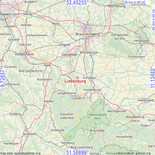
Liebenburg GPS coordinates[2]
52° 1' 18.336" North, 10° 25' 54.084" East
| Map corner | latitude | longitude |
|---|---|---|
| Upper-left | 52.45235°, | 9.72857° |
| Center: | 52.02176°, | 10.43169° |
| Lower-right: | 51.58699°, | 11.13482° |
| Map W x H: | 96.2×96.2 km | = 59.8×59.8mi |
| max Lat: | 55.01917° ⇑27.7% North |
| Liebenburg: | 52.02176° |
| min Lat: | ⇓72.3% South 47.40724° |
| min Long | Liebenburg | max Long |
| 5.92978° | 10.43169° | 14.98853° |
| W 57.7%⇐ | ⇒42.3% E |
Elevation
Elevation of Liebenburg is 132 m = 433 ft, and this is 117.1 m = 384 ft below average elevation for this country.
| Max E: |
1256 m = 4121 ft | 63% |
| Avg. | 249.1 m = 817 ft | |
| Liebenburg | 132 m = 433 ft | |
Min E: |
-5 m = -16 ft | 37% |
See also: Germany elevation on elevation.city.
Geographical zone
Liebenburg is located in North temperate zone (between Tropic of Cancer and the Arctic Circle). Distance of this North polar circle is 1616.9 km =1004.7 mi to North.| Distance of | km | miles | from Liebenburg |
|---|---|---|---|
| North Pole | 4222.8 | 2623.9 | to North |
| Arctic Circle | 1616.9 | 1004.7 | to North |
| Tropic Cancer | 3178.4 | 1975 | to South |
| Equator | 5784.3 | 3594.2 | to South |


Nearby cities:
15 places around Liebenburg: (largest is in red/bold)
• Alt Wallmoden
8.8 km =5.5 mi,  268°
268°
• Börßum
11.7 km =7.3 mi,  63°
63°
• Cramme
10.2 km =6.3 mi,  5°
5°
• Elbe
12.2 km =7.6 mi,  304°
304°
• Flöthe
7.7 km =4.8 mi,  27°
27°
• Gielde
4.5 km =2.8 mi,  69°
69°
• Heiningen
10 km =6.2 mi, 57°
• Hornburg
11.9 km =7.4 mi,  85°
85°
• Langelsheim
11.5 km =7.1 mi,  216°
216°
• Lutter am Barenberge
11.7 km =7.3 mi,  252°
252°
• Schladen
7.4 km =4.6 mi, 89°
• Sehlde
11.5 km =7.1 mi,  279°
279°
• Vienenburg
11.9 km =7.4 mi,  130°
130°
• Werlaburgdorf
7.9 km =4.9 mi, 66°
• Wülperode
12.3 km =7.6 mi,  111°
111°
Sources, notices
• [Note1] Compared only with cities in Germany existing in our database
• [Src1] Map data: © OpenStreetMap contributors (CC-BY-SA)
• [Src2] Other city data from geonames.org with taken over terms of usage.
• [Src3] Geographical zone / Annual Mean Temperature by Robert A. Rohde @ Wikipedia
