Geschwenda geodata
Geschwenda (Thuringia) is a seat of a fourth-order administrative division; located in Germany in Europe/Berlin (GMT+2) time zone. With population of 2,255 people, there are 4732 cities with bigger population in this country. Compared to other cities in Germany, 52.8% of cities are located further ↓South; 64.4% of cities are located further ←West and 85.2% of cities have lower elevation than Geschwenda. Note1


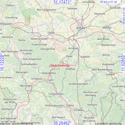
Geschwenda GPS coordinates[2]
50° 43' 54.408" North, 10° 49' 31.44" East
| Map corner | latitude | longitude |
|---|---|---|
| Upper-left | 51.17471°, | 10.12228° |
| Center: | 50.73178°, | 10.8254° |
| Lower-right: | 50.28462°, | 11.52853° |
| Map W x H: | 99×99 km | = 61.5×61.5mi |
| max Lat: | 55.01917° ⇑47.2% North |
| Geschwenda: | 50.73178° |
| min Lat: | ⇓52.8% South 47.40724° |
| min Long | Geschwenda | max Long |
| 5.92978° | 10.8254° | 14.98853° |
| W 64.4%⇐ | ⇒35.6% E |
Elevation
Elevation of Geschwenda is 471 m = 1545 ft, and this is 221.9 m = 728 ft above average elevation for this country.
| Max E: |
1256 m = 4121 ft | 14.8% |
| Geschwenda | 471 m 1545 ft | |
| Avg. | 249.1 m = 817 ft | |
Min E: |
-5 m = -16 ft | 85.2% |
See also: Germany elevation on elevation.city.
Geographical zone
Geschwenda is located in North temperate zone (between Tropic of Cancer and the Arctic Circle). Distance of this North polar circle is 1760.3 km =1093.8 mi to North.| Distance of | km | miles | from Geschwenda |
|---|---|---|---|
| North Pole | 4366.2 | 2713 | to North |
| Arctic Circle | 1760.3 | 1093.8 | to North |
| Tropic Cancer | 3034.9 | 1885.8 | to South |
| Equator | 5640.8 | 3505 | to South |


Nearby cities:
15 places around Geschwenda: (largest is in red/bold)
• Angelroda
3.2 km =2 mi,  63°
63°
• Crawinkel
6.5 km =4 mi,  332°
332°
• Elgersburg
3.5 km =2.2 mi,  145°
145°
• Frankenhain
3.8 km =2.4 mi,  316°
316°
• Gehlberg
6.4 km =4 mi,  202°
202°
• Geraberg
2 km =1.2 mi, 154°
• Gossel
7.8 km =4.8 mi,  12°
12°
• Gräfenroda
2.1 km =1.3 mi, 329°
• Ilmenau
8.5 km =5.3 mi,  129°
129°
• Liebenstein
4.2 km =2.6 mi,  24°
24°
• Luisenthal
8.6 km =5.3 mi,  311°
311°
• Martinroda
4.6 km =2.9 mi,  101°
101°
• Neusiß
4.7 km =2.9 mi,  72°
72°
• Oberhof
7.6 km =4.7 mi,  246°
246°
• Plaue
7.4 km =4.6 mi,  45°
45°
Sources, notices
• [Note1] Compared only with cities in Germany existing in our database
• [Src1] Map data: © OpenStreetMap contributors (CC-BY-SA)
• [Src2] Other city data from geonames.org with taken over terms of usage.
• [Src3] Geographical zone / Annual Mean Temperature by Robert A. Rohde @ Wikipedia
