Elgersburg geodata
Elgersburg (Thuringia) is a seat of a fourth-order administrative division; located in Germany in Europe/Berlin (GMT+2) time zone. With population of 1,234 people, there are 6483 cities with bigger population in this country. Compared to other cities in Germany, 52.3% of cities are located further ↓South; 64.8% of cities are located further ←West and 87.8% of cities have lower elevation than Elgersburg. Note1


Elgersburg GPS coordinates[2]
50° 42' 21.708" North, 10° 51' 11.16" East
| Map corner | latitude | longitude |
|---|---|---|
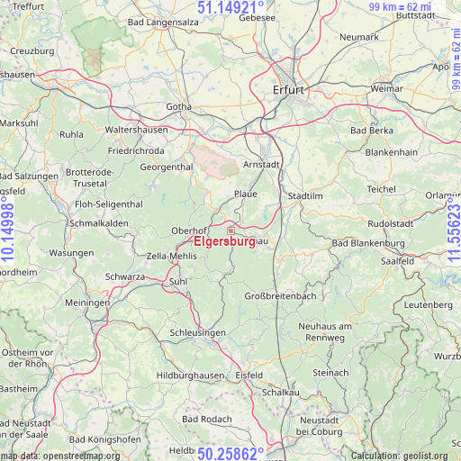
| Upper-left | 51.14921°, | 10.14998° |
| Center: | 50.70603°, | 10.8531° |
| Lower-right: | 50.25862°, | 11.55623° |
| Map W x H: | 99×99 km | = 61.5×61.5mi |
| max Lat: | 55.01917° ⇑47.7% North |
| Elgersburg: | 50.70603° |
| min Lat: | ⇓52.3% South 47.40724° |
| min Long | Elgersburg | max Long |
| 5.92978° | 10.8531° | 14.98853° |
| W 64.8%⇐ | ⇒35.2% E |
Elevation
Elevation of Elgersburg is 492 m = 1614 ft, and this is 242.9 m = 797 ft above average elevation for this country.
| Max E: |
1256 m = 4121 ft | 12.2% |
| Elgersburg | 492 m 1614 ft | |
| Avg. | 249.1 m = 817 ft | |
Min E: |
-5 m = -16 ft | 87.8% |
See also: Germany elevation on elevation.city.
Geographical zone
Elgersburg is located in North temperate zone (between Tropic of Cancer and the Arctic Circle). Distance of this North polar circle is 1763.2 km =1095.6 mi to North.| Distance of | km | miles | from Elgersburg |
|---|---|---|---|
| North Pole | 4369.1 | 2714.8 | to North |
| Arctic Circle | 1763.2 | 1095.6 | to North |
| Tropic Cancer | 3032.1 | 1884.1 | to South |
| Equator | 5638 | 3503.3 | to South |


Nearby cities:
15 places around Elgersburg: (largest is in red/bold)
• Angelroda
4.4 km =2.7 mi,  12°
12°
• Frankenhain
7.3 km =4.5 mi,  320°
320°
• Gehlberg
5.4 km =3.4 mi,  234°
234°
• Geraberg
1.6 km =1 mi,  314°
314°
• Geschwenda
3.5 km =2.2 mi,  325°
325°
• Gräfenroda
5.5 km =3.4 mi, 327°
• Ilmenau
5.3 km =3.3 mi,  118°
118°
• Langewiesen
9.1 km =5.7 mi,  114°
114°
• Liebenstein
6.7 km =4.2 mi,  358°
358°
• Martinroda
3.2 km =2 mi,  52°
52°
• Neuhaus
6.2 km =3.9 mi, 114°
• Neusiß
5 km =3.1 mi,  30°
30°
• Oberhof
8.9 km =5.5 mi,  268°
268°
• Plaue
8.7 km =5.4 mi,  22°
22°
• Stützerbach
8.1 km =5 mi,  173°
173°
Sources, notices
• [Note1] Compared only with cities in Germany existing in our database
• [Src1] Map data: © OpenStreetMap contributors (CC-BY-SA)
• [Src2] Other city data from geonames.org with taken over terms of usage.
• [Src3] Geographical zone / Annual Mean Temperature by Robert A. Rohde @ Wikipedia
