Gerabronn geodata
Gerabronn (Baden-Württemberg) is a populated place; located in Germany in Europe/Berlin (GMT+2) time zone. With population of 4,527 people, there are 3025 cities with bigger population in this country. Compared to other cities in Germany, 83.3% of cities are located further ↑North; 51.1% of cities are located further →East and 83.1% of cities have lower elevation than Gerabronn. Note1
Administrative division(s):
- Level 1: Baden-Württemberg
- Level 2: Regierungsbezirk Stuttgart
- Level 3: Landkreis Schwäbisch Hall
- Level 4: Bühlerzell


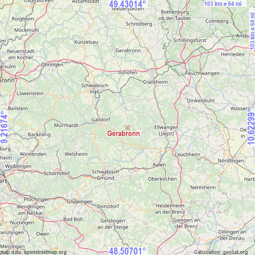
Gerabronn GPS coordinates[2]
48° 58' 14.556" North, 9° 55' 11.496" East
| Map corner | latitude | longitude |
|---|---|---|
| Upper-left | 49.43014°, | 9.21674° |
| Center: | 48.97071°, | 9.91986° |
| Lower-right: | 48.50701°, | 10.62299° |
| Map W x H: | 102.6×102.6 km | = 63.8×63.8mi |
| max Lat: | 55.01917° ⇑83.3% North |
| Gerabronn: | 48.97071° |
| min Lat: | ⇓16.7% South 47.40724° |
| min Long | Gerabronn | max Long |
| 5.92978° | 9.91986° | 14.98853° |
| W 48.9%⇐ | ⇒51.1% E |
Elevation
Elevation of Gerabronn is 454 m = 1490 ft, and this is 204.9 m = 672 ft above average elevation for this country.
| Max E: |
1256 m = 4121 ft | 16.9% |
| Gerabronn | 454 m 1490 ft | |
| Avg. | 249.1 m = 817 ft | |
Min E: |
-5 m = -16 ft | 83.1% |
See also: Germany elevation on elevation.city.
Geographical zone
Gerabronn is located in North temperate zone (between Tropic of Cancer and the Arctic Circle). Distance of this North polar circle is 1956.1 km =1215.5 mi to North.| Distance of | km | miles | from Gerabronn |
|---|---|---|---|
| North Pole | 4562 | 2834.7 | to North |
| Arctic Circle | 1956.1 | 1215.5 | to North |
| Tropic Cancer | 2839.1 | 1764.1 | to South |
| Equator | 5445 | 3383.4 | to South |


Nearby cities:
15 places around Gerabronn: (largest is in red/bold)
• Abtsgmünd
10.3 km =6.4 mi,  144°
144°
• Adelmannsfelden
6.4 km =4 mi,  105°
105°
• Bühlertann
7.9 km =4.9 mi,  354°
354°
• Bühlerzell
3.6 km =2.2 mi,  0°
0°
• Eschach
9.9 km =6.2 mi,  201°
201°
• Gaildorf
11.5 km =7.1 mi,  286°
286°
• Göggingen
12.5 km =7.8 mi,  192°
192°
• Heuchlingen
13.3 km =8.3 mi,  172°
172°
• Neuler
11.9 km =7.4 mi, 113°
• Obergröningen
8.5 km =5.3 mi, 185°
• Obersontheim
9.7 km =6 mi, 351°
• Rosenberg
9.6 km =6 mi,  56°
56°
• Ruppertshofen
12.4 km =7.7 mi,  218°
218°
• Schechingen
10.8 km =6.7 mi,  180°
180°
• Vellberg
13 km =8.1 mi, 346°
Sources, notices
• [Note1] Compared only with cities in Germany existing in our database
• [Src1] Map data: © OpenStreetMap contributors (CC-BY-SA)
• [Src2] Other city data from geonames.org with taken over terms of usage.
• [Src3] Geographical zone / Annual Mean Temperature by Robert A. Rohde @ Wikipedia
