Abtsgmünd geodata
Abtsgmünd (Baden-Württemberg) is a seat of a fourth-order administrative division; located in Germany in Europe/Berlin (GMT+2) time zone. With population of 7,381 people, there are 2096 cities with bigger population in this country. Compared to other cities in Germany, 84.1% of cities are located further ↑North; 50.1% of cities are located further ←West and 72% of cities have lower elevation than Abtsgmünd. Note1
Administrative division(s):
- Level 1: Baden-Württemberg
- Level 2: Regierungsbezirk Stuttgart
- Level 3: Ostalbkreis
- Level 4: Abtsgmünd


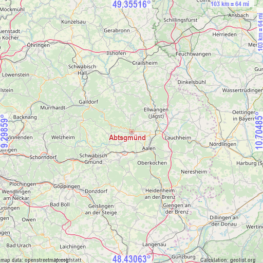
Abtsgmünd GPS coordinates[2]
48° 53' 42.108" North, 10° 0' 6.192" East
| Map corner | latitude | longitude |
|---|---|---|
| Upper-left | 49.35516°, | 9.29859° |
| Center: | 48.89503°, | 10.00172° |
| Lower-right: | 48.43063°, | 10.70485° |
| Map W x H: | 102.8×102.8 km | = 63.9×63.9mi |
| max Lat: | 55.01917° ⇑84.1% North |
| Abtsgmünd: | 48.89503° |
| min Lat: | ⇓15.9% South 47.40724° |
| min Long | Abtsgmünd | max Long |
| 5.92978° | 10.00172° | 14.98853° |
| W 50.1%⇐ | ⇒49.9% E |
Elevation
Elevation of Abtsgmünd is 374 m = 1227 ft, and this is 124.9 m = 410 ft above average elevation for this country.
| Max E: |
1256 m = 4121 ft | 28% |
| Abtsgmünd | 374 m 1227 ft | |
| Avg. | 249.1 m = 817 ft | |
Min E: |
-5 m = -16 ft | 72% |
See also: Germany elevation on elevation.city.
Geographical zone
Abtsgmünd is located in North temperate zone (between Tropic of Cancer and the Arctic Circle). Distance of this North polar circle is 1964.6 km =1220.7 mi to North.| Distance of | km | miles | from Abtsgmünd |
|---|---|---|---|
| North Pole | 4570.4 | 2839.9 | to North |
| Arctic Circle | 1964.6 | 1220.7 | to North |
| Tropic Cancer | 2830.7 | 1758.9 | to South |
| Equator | 5436.6 | 3378.1 | to South |


Nearby cities:
15 places around Abtsgmünd: (largest is in red/bold)
• Aalen
9.2 km =5.7 mi,  133°
133°
• Adelmannsfelden
6.6 km =4.1 mi,  1°
1°
• Böbingen an der Rems
10.2 km =6.3 mi,  215°
215°
• Eschach
9.7 km =6 mi,  265°
265°
• Essingen
9.8 km =6.1 mi,  168°
168°
• Gerabronn
10.3 km =6.4 mi,  324°
324°
• Göggingen
9.4 km =5.8 mi,  246°
246°
• Heuchlingen
6.4 km =4 mi, 221°
• Hüttlingen
7.2 km =4.5 mi,  92°
92°
• Iggingen
11.4 km =7.1 mi,  231°
231°
• Leinzell
10.4 km =6.5 mi,  240°
240°
• Mögglingen
8.5 km =5.3 mi,  199°
199°
• Neuler
6.1 km =3.8 mi,  53°
53°
• Obergröningen
6.7 km =4.2 mi, 269°
• Schechingen
6.6 km =4.1 mi, 248°
Sources, notices
• [Note1] Compared only with cities in Germany existing in our database
• [Src1] Map data: © OpenStreetMap contributors (CC-BY-SA)
• [Src2] Other city data from geonames.org with taken over terms of usage.
• [Src3] Geographical zone / Annual Mean Temperature by Robert A. Rohde @ Wikipedia
