Göggingen geodata
Göggingen (Baden-Württemberg) is a seat of a fourth-order administrative division; located in Germany in Europe/Berlin (GMT+2) time zone. With population of 2,496 people, there are 4445 cities with bigger population in this country. Compared to other cities in Germany, 84.5% of cities are located further ↑North; 51.6% of cities are located further →East and 87.7% of cities have lower elevation than Göggingen. Note1
Administrative division(s):
- Level 1: Baden-Württemberg
- Level 2: Regierungsbezirk Stuttgart
- Level 3: Ostalbkreis
- Level 4: Göggingen


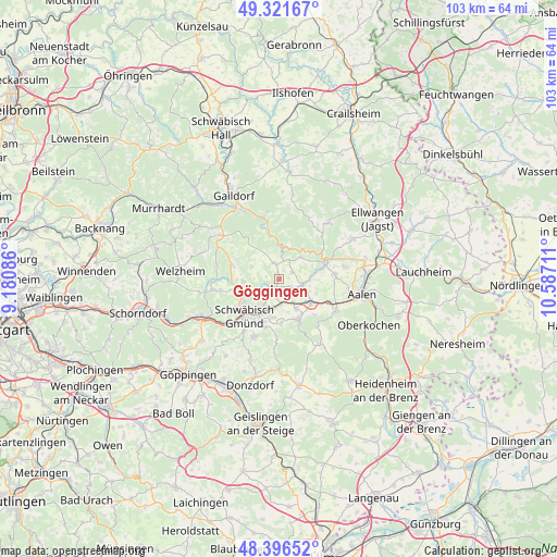
Göggingen GPS coordinates[2]
48° 51' 40.428" North, 9° 53' 2.328" East
| Map corner | latitude | longitude |
|---|---|---|
| Upper-left | 49.32167°, | 9.18086° |
| Center: | 48.86123°, | 9.88398° |
| Lower-right: | 48.39652°, | 10.58711° |
| Map W x H: | 102.9×102.9 km | = 63.9×63.9mi |
| max Lat: | 55.01917° ⇑84.5% North |
| Göggingen: | 48.86123° |
| min Lat: | ⇓15.5% South 47.40724° |
| min Long | Göggingen | max Long |
| 5.92978° | 9.88398° | 14.98853° |
| W 48.4%⇐ | ⇒51.6% E |
Elevation
Elevation of Göggingen is 491 m = 1611 ft, and this is 241.9 m = 794 ft above average elevation for this country.
| Max E: |
1256 m = 4121 ft | 12.3% |
| Göggingen | 491 m 1611 ft | |
| Avg. | 249.1 m = 817 ft | |
Min E: |
-5 m = -16 ft | 87.7% |
See also: Germany elevation on elevation.city.
Geographical zone
Göggingen is located in North temperate zone (between Tropic of Cancer and the Arctic Circle). Distance of this North polar circle is 1968.3 km =1223 mi to North.| Distance of | km | miles | from Göggingen |
|---|---|---|---|
| North Pole | 4574.2 | 2842.3 | to North |
| Arctic Circle | 1968.3 | 1223 | to North |
| Tropic Cancer | 2826.9 | 1756.6 | to South |
| Equator | 5432.9 | 3375.8 | to South |


Nearby cities:
15 places around Göggingen: (largest is in red/bold)
• Böbingen an der Rems
5.4 km =3.4 mi,  149°
149°
• Durlangen
6.4 km =4 mi,  265°
265°
• Eschach
3.2 km =2 mi,  341°
341°
• Heubach
8.4 km =5.2 mi, 154°
• Heuchlingen
4.5 km =2.8 mi,  102°
102°
• Iggingen
3.3 km =2.1 mi,  186°
186°
• Leinzell
1.4 km =0.9 mi,  199°
199°
• Mutlangen
7.5 km =4.7 mi,  238°
238°
• Mögglingen
7.1 km =4.4 mi,  126°
126°
• Obergröningen
4.1 km =2.5 mi,  26°
26°
• Ruppertshofen
5.6 km =3.5 mi,  295°
295°
• Schechingen
2.8 km =1.7 mi,  61°
61°
• Schwäbisch Gmünd
9.3 km =5.8 mi,  222°
222°
• Spraitbach
9.2 km =5.7 mi,  283°
283°
• Täferrot
3.6 km =2.2 mi,  249°
249°
Sources, notices
• [Note1] Compared only with cities in Germany existing in our database
• [Src1] Map data: © OpenStreetMap contributors (CC-BY-SA)
• [Src2] Other city data from geonames.org with taken over terms of usage.
• [Src3] Geographical zone / Annual Mean Temperature by Robert A. Rohde @ Wikipedia
