Gaildorf geodata
Gaildorf (Baden-Württemberg) is a populated place; located in Germany in Europe/Berlin (GMT+2) time zone. With population of 12,571 people, there are 1289 cities with bigger population in this country. Compared to other cities in Germany, 83% of cities are located further ↑North; 53.2% of cities are located further →East and 67.2% of cities have lower elevation than Gaildorf. Note1
Administrative division(s):
- Level 1: Baden-Württemberg
- Level 2: Regierungsbezirk Stuttgart
- Level 3: Landkreis Schwäbisch Hall
- Level 4: Gaildorf


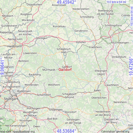
Gaildorf GPS coordinates[2]
49° 0' 0.972" North, 9° 46' 10.308" East
| Map corner | latitude | longitude |
|---|---|---|
| Upper-left | 49.45942°, | 9.06641° |
| Center: | 49.00027°, | 9.76953° |
| Lower-right: | 48.53684°, | 10.47266° |
| Map W x H: | 102.6×102.6 km | = 63.8×63.8mi |
| max Lat: | 55.01917° ⇑83% North |
| Gaildorf: | 49.00027° |
| min Lat: | ⇓17% South 47.40724° |
| min Long | Gaildorf | max Long |
| 5.92978° | 9.76953° | 14.98853° |
| W 46.8%⇐ | ⇒53.2% E |
Elevation
Elevation of Gaildorf is 337 m = 1106 ft, and this is 87.9 m = 288 ft above average elevation for this country.
| Max E: |
1256 m = 4121 ft | 32.8% |
| Gaildorf | 337 m 1106 ft | |
| Avg. | 249.1 m = 817 ft | |
Min E: |
-5 m = -16 ft | 67.2% |
See also: Germany elevation on elevation.city.
Geographical zone
Gaildorf is located in North temperate zone (between Tropic of Cancer and the Arctic Circle). Distance of this North polar circle is 1952.9 km =1213.5 mi to North.| Distance of | km | miles | from Gaildorf |
|---|---|---|---|
| North Pole | 4558.7 | 2832.6 | to North |
| Arctic Circle | 1952.9 | 1213.5 | to North |
| Tropic Cancer | 2842.4 | 1766.2 | to South |
| Equator | 5448.3 | 3385.4 | to South |


Nearby cities:
15 places around Gaildorf: (largest is in red/bold)
• Bühlertann
11.1 km =6.9 mi,  65°
65°
• Bühlerzell
11 km =6.8 mi,  88°
88°
• Eschach
14.4 km =8.9 mi,  149°
149°
• Fichtenberg
4.5 km =2.8 mi,  249°
249°
• Gerabronn
11.5 km =7.1 mi,  106°
106°
• Gschwend
7.7 km =4.8 mi,  193°
193°
• Kaisersbach
12.3 km =7.6 mi,  230°
230°
• Michelbach an der Bilz
7.8 km =4.8 mi,  356°
356°
• Michelfeld
12.7 km =7.9 mi,  328°
328°
• Oberrot
7.6 km =4.7 mi,  281°
281°
• Obersontheim
11.3 km =7 mi,  56°
56°
• Ruppertshofen
13.5 km =8.4 mi,  165°
165°
• Schwäbisch Hall
12.5 km =7.8 mi,  349°
349°
• Spraitbach
13.3 km =8.3 mi,  182°
182°
• Vellberg
12.3 km =7.6 mi,  40°
40°
Sources, notices
• [Note1] Compared only with cities in Germany existing in our database
• [Src1] Map data: © OpenStreetMap contributors (CC-BY-SA)
• [Src2] Other city data from geonames.org with taken over terms of usage.
• [Src3] Geographical zone / Annual Mean Temperature by Robert A. Rohde @ Wikipedia
