Geisleden geodata
Geisleden (Thuringia) is a seat of a fourth-order administrative division; located in Germany in Europe/Berlin (GMT+2) time zone. With population of 1,167 people, there are 6656 cities with bigger population in this country. Compared to other cities in Germany, 63.9% of cities are located further ↓South; 53.3% of cities are located further ←West and 66% of cities have lower elevation than Geisleden. Note1


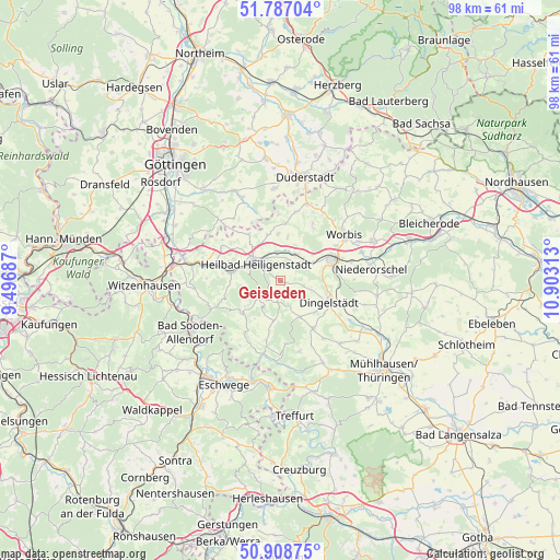
Geisleden GPS coordinates[2]
51° 21' 0" North, 10° 12' 0" East
| Map corner | latitude | longitude |
|---|---|---|
| Upper-left | 51.78704°, | 9.49687° |
| Center: | 51.35°, | 10.2° |
| Lower-right: | 50.90875°, | 10.90313° |
| Map W x H: | 97.7×97.7 km | = 60.7×60.7mi |
| max Lat: | 55.01917° ⇑36.1% North |
| Geisleden: | 51.35° |
| min Lat: | ⇓63.9% South 47.40724° |
| min Long | Geisleden | max Long |
| 5.92978° | 10.2° | 14.98853° |
| W 53.3%⇐ | ⇒46.7% E |
Elevation
Elevation of Geisleden is 328 m = 1076 ft, and this is 78.9 m = 259 ft above average elevation for this country.
| Max E: |
1256 m = 4121 ft | 34% |
| Geisleden | 328 m 1076 ft | |
| Avg. | 249.1 m = 817 ft | |
Min E: |
-5 m = -16 ft | 66% |
See also: Germany elevation on elevation.city.
Geographical zone
Geisleden is located in North temperate zone (between Tropic of Cancer and the Arctic Circle). Distance of this North polar circle is 1691.6 km =1051.1 mi to North.| Distance of | km | miles | from Geisleden |
|---|---|---|---|
| North Pole | 4297.5 | 2670.3 | to North |
| Arctic Circle | 1691.6 | 1051.1 | to North |
| Tropic Cancer | 3103.7 | 1928.5 | to South |
| Equator | 5709.6 | 3547.8 | to South |


Nearby cities:
15 places around Geisleden: (largest is in red/bold)
• Dieterode
8.9 km =5.5 mi,  231°
231°
• Dingelstädt
9 km =5.6 mi,  115°
115°
• Heilbad Heiligenstadt
5.4 km =3.4 mi,  305°
305°
• Heuthen
2.5 km =1.6 mi,  142°
142°
• Kallmerode
6.9 km =4.3 mi,  90°
90°
• Kefferhausen
6.9 km =4.3 mi, 122°
• Kreuzebra
3.5 km =2.2 mi, 90°
• Krombach
7.2 km =4.5 mi,  219°
219°
• Lenterode
9.4 km =5.8 mi,  258°
258°
• Lutter
6.1 km =3.8 mi,  252°
252°
• Reinholterode
8 km =5 mi,  357°
357°
• Steinbach
8.1 km =5 mi,  9°
9°
• Uder
9 km =5.6 mi,  278°
278°
• Wachstedt
6.6 km =4.1 mi,  147°
147°
• Wingerode
5.3 km =3.3 mi,  31°
31°
Sources, notices
• [Note1] Compared only with cities in Germany existing in our database
• [Src1] Map data: © OpenStreetMap contributors (CC-BY-SA)
• [Src2] Other city data from geonames.org with taken over terms of usage.
• [Src3] Geographical zone / Annual Mean Temperature by Robert A. Rohde @ Wikipedia
