Dingelstädt geodata
Dingelstädt (Thuringia) is a populated place; located in Germany in Europe/Berlin (GMT+2) time zone. With population of 4,878 people, there are 2867 cities with bigger population in this country. Compared to other cities in Germany, 63.5% of cities are located further ↓South; 55.8% of cities are located further ←West and 67.2% of cities have lower elevation than Dingelstädt. Note1


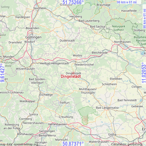
Dingelstädt GPS coordinates[2]
51° 18' 55.044" North, 10° 19' 2.64" East
| Map corner | latitude | longitude |
|---|---|---|
| Upper-left | 51.75266°, | 9.61427° |
| Center: | 51.31529°, | 10.3174° |
| Lower-right: | 50.87371°, | 11.02053° |
| Map W x H: | 97.7×97.7 km | = 60.7×60.7mi |
| max Lat: | 55.01917° ⇑36.5% North |
| Dingelstädt: | 51.31529° |
| min Lat: | ⇓63.5% South 47.40724° |
| min Long | Dingelstädt | max Long |
| 5.92978° | 10.3174° | 14.98853° |
| W 55.8%⇐ | ⇒44.2% E |
Elevation
Elevation of Dingelstädt is 337 m = 1106 ft, and this is 87.9 m = 288 ft above average elevation for this country.
| Max E: |
1256 m = 4121 ft | 32.8% |
| Dingelstädt | 337 m 1106 ft | |
| Avg. | 249.1 m = 817 ft | |
Min E: |
-5 m = -16 ft | 67.2% |
See also: Germany elevation on elevation.city.
Geographical zone
Dingelstädt is located in North temperate zone (between Tropic of Cancer and the Arctic Circle). Distance of this North polar circle is 1695.4 km =1053.5 mi to North.| Distance of | km | miles | from Dingelstädt |
|---|---|---|---|
| North Pole | 4301.3 | 2672.7 | to North |
| Arctic Circle | 1695.4 | 1053.5 | to North |
| Tropic Cancer | 3099.8 | 1926.1 | to South |
| Equator | 5705.7 | 3545.4 | to South |


Nearby cities:
15 places around Dingelstädt: (largest is in red/bold)
• Anrode
5.5 km =3.4 mi,  168°
168°
• Büttstedt
6.2 km =3.9 mi,  187°
187°
• Geisleden
9 km =5.6 mi,  295°
295°
• Hausen
8.3 km =5.2 mi,  24°
24°
• Helmsdorf
2.8 km =1.7 mi,  126°
126°
• Heuthen
6.9 km =4.3 mi,  285°
285°
• Kallmerode
4 km =2.5 mi,  342°
342°
• Kefferhausen
2.4 km =1.5 mi,  273°
273°
• Kleinbartloff
6 km =3.7 mi,  49°
49°
• Kreuzebra
6.1 km =3.8 mi,  309°
309°
• Küllstedt
5.1 km =3.2 mi,  210°
210°
• Leinefelde-Worbis
8.1 km =5 mi,  4°
4°
• Niederorschel
9.7 km =6 mi, 49°
• Silberhausen
1.6 km =1 mi,  107°
107°
• Wachstedt
5 km =3.1 mi,  250°
250°
Sources, notices
• [Note1] Compared only with cities in Germany existing in our database
• [Src1] Map data: © OpenStreetMap contributors (CC-BY-SA)
• [Src2] Other city data from geonames.org with taken over terms of usage.
• [Src3] Geographical zone / Annual Mean Temperature by Robert A. Rohde @ Wikipedia
