Drage geodata
Drage (Lower Saxony) is a seat of a fourth-order administrative division; located in Germany in Europe/Berlin (GMT+2) time zone. With population of 3,623 people, there are 3521 cities with bigger population in this country. Compared to other cities in Germany, 84.7% of cities are located further ↓South; 54.6% of cities are located further ←West and 97.6% of cities have higher elevation than Drage. Note1


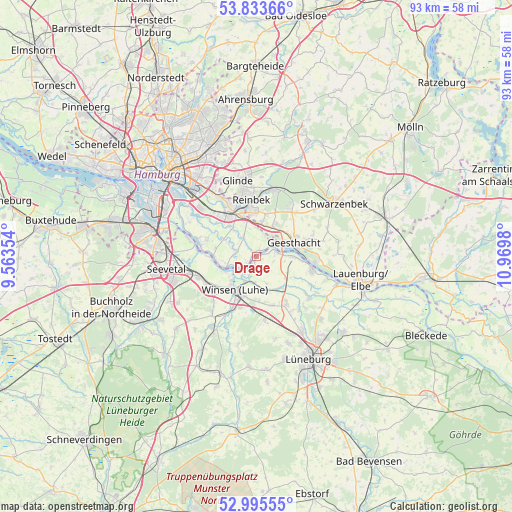
Drage GPS coordinates[2]
53° 25' 0.012" North, 10° 16' 0.012" East
| Map corner | latitude | longitude |
|---|---|---|
| Upper-left | 53.83366°, | 9.56354° |
| Center: | 53.41667°, | 10.26667° |
| Lower-right: | 52.99555°, | 10.9698° |
| Map W x H: | 93.2×93.2 km | = 57.9×57.9mi |
| max Lat: | 55.01917° ⇑15.3% North |
| Drage: | 53.41667° |
| min Lat: | ⇓84.7% South 47.40724° |
| min Long | Drage | max Long |
| 5.92978° | 10.26667° | 14.98853° |
| W 54.6%⇐ | ⇒45.4% E |
Elevation
Elevation of Drage is 3 m = 10 ft, and this is 246.1 m = 807 ft below average elevation for this country.
| Max E: |
1256 m = 4121 ft | 97.6% |
| Avg. | 249.1 m = 817 ft | |
| Drage | 3 m = 10 ft | |
Min E: |
-5 m = -16 ft | 2.4% |
See also: Germany elevation on elevation.city.
Geographical zone
Drage is located in North temperate zone (between Tropic of Cancer and the Arctic Circle). Distance of this North polar circle is 1461.8 km =908.3 mi to North.| Distance of | km | miles | from Drage |
|---|---|---|---|
| North Pole | 4067.7 | 2527.6 | to North |
| Arctic Circle | 1461.8 | 908.3 | to North |
| Tropic Cancer | 3333.5 | 2071.3 | to South |
| Equator | 5939.4 | 3690.6 | to South |


Nearby cities:
15 places around Drage: (largest is in red/bold)
• Bergedorf
8 km =5 mi,  341°
341°
• Börnsen
6.7 km =4.2 mi,  8°
8°
• Dassendorf
10.7 km =6.6 mi,  35°
35°
• Escheburg
6.5 km =4 mi,  30°
30°
• Geesthacht
7.7 km =4.8 mi,  73°
73°
• Hamwarde
10.6 km =6.6 mi, 69°
• Handorf
10 km =6.2 mi,  147°
147°
• Hohenhorn
9.3 km =5.8 mi, 44°
• Kröppelshagen-Fahrendorf
8.8 km =5.5 mi,  22°
22°
• Marschacht
7.2 km =4.5 mi,  91°
91°
• Stelle
10.9 km =6.8 mi,  250°
250°
• Tespe
9.8 km =6.1 mi,  103°
103°
• Wentorf bei Hamburg
9.3 km =5.8 mi,  353°
353°
• Winsen
7.5 km =4.7 mi,  208°
208°
• Wohltorf
11.2 km =7 mi, 5°
Sources, notices
• [Note1] Compared only with cities in Germany existing in our database
• [Src1] Map data: © OpenStreetMap contributors (CC-BY-SA)
• [Src2] Other city data from geonames.org with taken over terms of usage.
• [Src3] Geographical zone / Annual Mean Temperature by Robert A. Rohde @ Wikipedia
