Dassendorf geodata
Dassendorf (Schleswig-Holstein) is a seat of a fourth-order administrative division; located in Germany in Europe/Berlin (GMT+2) time zone. With population of 3,148 people, there are 3873 cities with bigger population in this country. Compared to other cities in Germany, 85.5% of cities are located further ↓South; 56.5% of cities are located further ←West and 76.4% of cities have higher elevation than Dassendorf. Note1
Administrative division(s):
- Level 1: Schleswig-Holstein
- Level 3: Kreis Herzogtum Lauenburg
- Level 4: Dassendorf


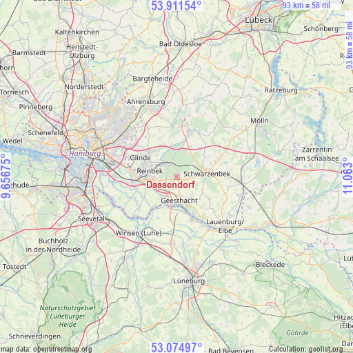
Dassendorf GPS coordinates[2]
53° 29' 43.152" North, 10° 21' 35.532" East
| Map corner | latitude | longitude |
|---|---|---|
| Upper-left | 53.91154°, | 9.65675° |
| Center: | 53.49532°, | 10.35987° |
| Lower-right: | 53.07497°, | 11.063° |
| Map W x H: | 93×93 km | = 57.8×57.8mi |
| max Lat: | 55.01917° ⇑14.5% North |
| Dassendorf: | 53.49532° |
| min Lat: | ⇓85.5% South 47.40724° |
| min Long | Dassendorf | max Long |
| 5.92978° | 10.35987° | 14.98853° |
| W 56.5%⇐ | ⇒43.5% E |
Elevation
Elevation of Dassendorf is 58 m = 190 ft, and this is 191.1 m = 627 ft below average elevation for this country.
| Max E: |
1256 m = 4121 ft | 76.4% |
| Avg. | 249.1 m = 817 ft | |
| Dassendorf | 58 m = 190 ft | |
Min E: |
-5 m = -16 ft | 23.6% |
See also: Germany elevation on elevation.city.
Geographical zone
Dassendorf is located in North temperate zone (between Tropic of Cancer and the Arctic Circle). Distance of this North polar circle is 1453.1 km =902.9 mi to North.| Distance of | km | miles | from Dassendorf |
|---|---|---|---|
| North Pole | 4058.9 | 2522.1 | to North |
| Arctic Circle | 1453.1 | 902.9 | to North |
| Tropic Cancer | 3342.2 | 2076.7 | to South |
| Equator | 5948.1 | 3696 | to South |


Nearby cities:
15 places around Dassendorf: (largest is in red/bold)
• Bergedorf
8.7 km =5.4 mi,  262°
262°
• Brunstorf
4.3 km =2.7 mi,  92°
92°
• Börnsen
5.6 km =3.5 mi,  247°
247°
• Escheburg
4.3 km =2.7 mi,  221°
221°
• Geesthacht
6.7 km =4.2 mi,  169°
169°
• Hamwarde
6.3 km =3.9 mi,  143°
143°
• Hohenhorn
2.1 km =1.3 mi, 171°
• Kollow
7.8 km =4.8 mi,  114°
114°
• Kröppelshagen-Fahrendorf
2.9 km =1.8 mi, 257°
• Reinbek
7.7 km =4.8 mi,  288°
288°
• Schwarzenbek
8 km =5 mi,  83°
83°
• Wentorf bei Hamburg
7.3 km =4.5 mi,  274°
274°
• Witzhave
8.1 km =5 mi,  347°
347°
• Wohltorf
5.6 km =3.5 mi,  295°
295°
• Worth
4.9 km =3 mi,  130°
130°
Sources, notices
• [Note1] Compared only with cities in Germany existing in our database
• [Src1] Map data: © OpenStreetMap contributors (CC-BY-SA)
• [Src2] Other city data from geonames.org with taken over terms of usage.
• [Src3] Geographical zone / Annual Mean Temperature by Robert A. Rohde @ Wikipedia
