Schwedt (Oder) geodata
Schwedt (Oder) (Brandenburg) is a populated place; located in Germany in Europe/Berlin (GMT+2) time zone. With population of 38,001 people, there are 348 cities with bigger population in this country. Compared to other cities in Germany, 82.1% of cities are located further ↓South; 98.9% of cities are located further ←West and 98.1% of cities have higher elevation than Schwedt (Oder). Note1


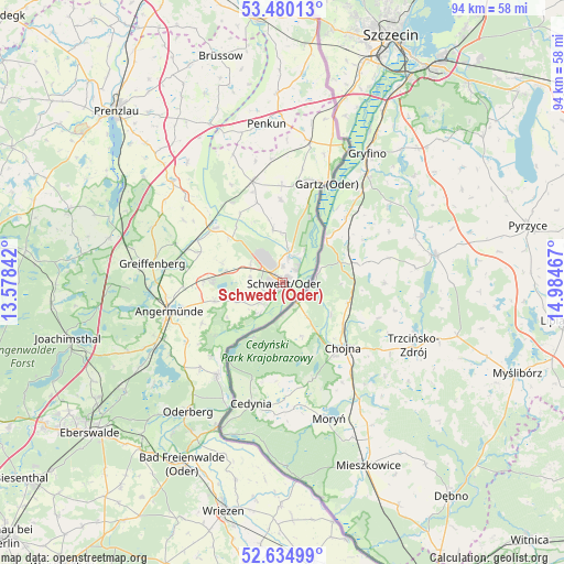
Schwedt (Oder) GPS coordinates[2]
53° 3' 34.668" North, 14° 16' 53.544" East
| Map corner | latitude | longitude |
|---|---|---|
| Upper-left | 53.48013°, | 13.57842° |
| Center: | 53.05963°, | 14.28154° |
| Lower-right: | 52.63499°, | 14.98467° |
| Map W x H: | 94×94 km | = 58.4×58.4mi |
| max Lat: | 55.01917° ⇑17.9% North |
| Schwedt (Oder): | 53.05963° |
| min Lat: | ⇓82.1% South 47.40724° |
| min Long | Schwedt (Oder) | max Long |
| 5.92978° | 14.28154° | 14.98853° |
| W 98.9%⇐ | ⇒1.1% E |
Elevation
Elevation of Schwedt (Oder) is 2 m = 7 ft, and this is 247.1 m = 811 ft below average elevation for this country.
| Max E: |
1256 m = 4121 ft | 98.1% |
| Avg. | 249.1 m = 817 ft | |
| Schwedt (Oder) | 2 m = 7 ft | |
Min E: |
-5 m = -16 ft | 1.9% |
See also: Germany elevation on elevation.city.
Geographical zone
Schwedt (Oder) is located in North temperate zone (between Tropic of Cancer and the Arctic Circle). Distance of this North polar circle is 1501.5 km =933 mi to North.| Distance of | km | miles | from Schwedt (Oder) |
|---|---|---|---|
| North Pole | 4107.4 | 2552.2 | to North |
| Arctic Circle | 1501.5 | 933 | to North |
| Tropic Cancer | 3293.8 | 2046.7 | to South |
| Equator | 5899.7 | 3665.9 | to South |


Nearby cities:
15 places around Schwedt (Oder): (largest is in red/bold)
• Angermünde
19.5 km =12.1 mi,  255°
255°
• Casekow
17.5 km =10.9 mi,  343°
343°
• Gartz
18.1 km =11.2 mi,  24°
24°
• Gramzow
25 km =15.5 mi,  312°
312°
• Hohensaaten
22.6 km =14 mi,  204°
204°
• Liepe
30.3 km =18.8 mi,  223°
223°
• Mescherin
23.1 km =14.4 mi,  25°
25°
• Meyenburg
3.4 km =2.1 mi,  241°
241°
• Oderberg
26.8 km =16.7 mi, 216°
• Passow
14.5 km =9 mi, 309°
• Penkun
26.6 km =16.5 mi,  353°
353°
• Pinnow
13.1 km =8.1 mi,  271°
271°
• Schöneberg
10.9 km =6.8 mi, 238°
• Tantow
24 km =14.9 mi,  11°
11°
• Zichow
21.7 km =13.5 mi, 311°
Sources, notices
• [Note1] Compared only with cities in Germany existing in our database
• [Src1] Map data: © OpenStreetMap contributors (CC-BY-SA)
• [Src2] Other city data from geonames.org with taken over terms of usage.
• [Src3] Geographical zone / Annual Mean Temperature by Robert A. Rohde @ Wikipedia
