Gars geodata
Gars (Bavaria) is a populated place; located in Germany in Europe/Berlin (GMT+2) time zone. With population of 3,802 people, there are 3402 cities with bigger population in this country. Compared to other cities in Germany, 93.3% of cities are located further ↑North; 85.6% of cities are located further ←West and 81.7% of cities have lower elevation than Gars. Note1
Administrative division(s):
- Level 1: Bavaria
- Level 2: Upper Bavaria
- Level 3: Landkreis Mühldorf am Inn
- Level 4: Gars a.Inn, Markt


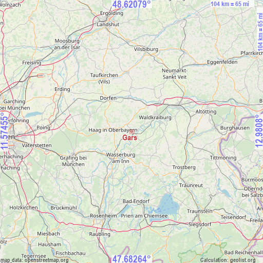
Gars GPS coordinates[2]
48° 9' 13.896" North, 12° 16' 39.612" East
| Map corner | latitude | longitude |
|---|---|---|
| Upper-left | 48.62079°, | 11.57455° |
| Center: | 48.15386°, | 12.27767° |
| Lower-right: | 47.68264°, | 12.9808° |
| Map W x H: | 104.3×104.3 km | = 64.8×64.8mi |
| max Lat: | 55.01917° ⇑93.3% North |
| Gars: | 48.15386° |
| min Lat: | ⇓6.7% South 47.40724° |
| min Long | Gars | max Long |
| 5.92978° | 12.27767° | 14.98853° |
| W 85.6%⇐ | ⇒14.4% E |
Elevation
Elevation of Gars is 444 m = 1457 ft, and this is 194.9 m = 639 ft above average elevation for this country.
| Max E: |
1256 m = 4121 ft | 18.3% |
| Gars | 444 m 1457 ft | |
| Avg. | 249.1 m = 817 ft | |
Min E: |
-5 m = -16 ft | 81.7% |
See also: Germany elevation on elevation.city.
Geographical zone
Gars is located in North temperate zone (between Tropic of Cancer and the Arctic Circle). Distance of this North polar circle is 2047 km =1271.9 mi to North.| Distance of | km | miles | from Gars |
|---|---|---|---|
| North Pole | 4652.9 | 2891.2 | to North |
| Arctic Circle | 2047 | 1271.9 | to North |
| Tropic Cancer | 2748.3 | 1707.7 | to South |
| Equator | 5354.2 | 3326.9 | to South |


Nearby cities:
15 places around Gars: (largest is in red/bold)
• Altdorf
6.9 km =4.3 mi,  269°
269°
• Aschau am Inn
7.3 km =4.5 mi,  47°
47°
• Babensham
7.9 km =4.9 mi,  185°
185°
• Haag in Oberbayern
7.3 km =4.5 mi,  277°
277°
• Jettenbach
8 km =5 mi,  79°
79°
• Kirchdorf
6.5 km =4 mi,  291°
291°
• Ramsau
4.1 km =2.5 mi,  300°
300°
• Rattenkirchen
10.2 km =6.3 mi,  15°
15°
• Rechtmehring
9.2 km =5.7 mi,  243°
243°
• Reichertsheim
5.1 km =3.2 mi,  4°
4°
• Schnaitsee
11.7 km =7.3 mi,  145°
145°
• Schönberg
10.5 km =6.5 mi,  176°
176°
• Soyen
7.1 km =4.4 mi,  224°
224°
• Unterreit
5.8 km =3.6 mi,  135°
135°
• Waldkraiburg
10.9 km =6.8 mi,  55°
55°
Sources, notices
• [Note1] Compared only with cities in Germany existing in our database
• [Src1] Map data: © OpenStreetMap contributors (CC-BY-SA)
• [Src2] Other city data from geonames.org with taken over terms of usage.
• [Src3] Geographical zone / Annual Mean Temperature by Robert A. Rohde @ Wikipedia
